Return to sea

Welcome back to Halley’s Log!

We left Captain Halley last September, newly returned to London and working on his Atlantic chart of magnetic variation, which he formally presented to the Royal Society on 4 June 1701.

But while Edmond had quickly resumed his old habits of attending Royal Society meetings and discoursing endlessly in coffeehouses, the sea was never far from his mind, and on 23 April 1701 he sent this proposal to the Lords of the Admiralty (remember “Lopps” is Halley’s abbreviation for “Lordshipps”):

It is humbly proposed

That if their Lopps shall think fitting to have an exact account of the Course of the Tides on and about the Coast of England, so taken as at one View to represent the whole; (which will be a work of generall Use to all Shipping, especially such as have occasion to turn to Windward, and wch is wanting towards the compleating the Art of Navigation) there be provided a small Vessell such as their Lopps shall think proper, with all convenient speed, on board of which such an account of the Tides may be taken, as their Lopps shall direct; for which service their Lopps most obedient servant humbly offers himself.

Edm. Halley [1]

Their Lopps did think it fitting to have the course of the tides around the southern coast of England observed and gave the order for a vessel – yes, the Paramore Pink – to be prepared for Halley’s third expedition.

So Captain Halley expects to put back to sea very very soon – there’s just the one small matter of a crew to recruit…

_______________

[1] Halley to the Lords Commissioners of the Admiralty, 23 April 1701, TNA, ADM 1/1872

The end of Halley’s second voyage

Halley arrived back in Deptford from his second voyage on 10 September 1700 and he’ll return to sea for his third voyage in June 1701 (June 2015 by the life of this blog), so I thought I’d close this phase of my project by looking at some of the things that Edmond will be doing in the intervening months.

As we’ve seen (here and here), he began preparing his chart of magnetic variation as soon as he returned to London and there are periodic entries in the Royal Society minutes of his showing (what are assumed to be) manuscript drafts of his chart at their meetings. He presented a copy formally to the Society on 4 June 1701, when the minutes record:

Mr Halley presented the Society with a Map of his late Voiage to the South. He was thanked for it, & it was order’d to be hung in the Meeting room. [1]

The exact publication date of the chart isn’t known but is assumed to have been during the second quarter of 1701 (given its presentation date to the RS), and it occurs to me that a letter dated 6 May 1701 from the Admiralty to the Navy Board, awarding a bonus of £200 to Halley on the order of the king, may have been prompted by the publication of his chart:

In obedience to his Mats. [Majesty’s] Commands signified to this Board, Wee do hereby desire and direct you to cause to be paid unto Captn. Edward [sic] Halley, out of the Money in the hands of the Trea[sure]r of the Navy upon Acct. of the Tenths of Prizes the sum of two Hundred Pounds, in consideration of his great Paines and care in a late Voyage he made for the discovering the Variation of the Needle. [2]

Halley resumed his attendance at Royal Society meetings when they reconvened after their summer recess, and, having resigned his Fellowship in 1686 to become the Society’s clerk, he was re-elected FRS at the General Meeting of 30 November 1700 and voted one of the auditors of their accounts on December 17. [3]

Halley was often referred to as “Capt Halley” in the Society’s minutes of this period, but it’s somewhat surprising how few references there are to his voyage; I assume Edmond mostly talked about his expedition in the coffeehouses.

Halley by Kneller (NMM Ref)

Halley, by Kneller (© NMM, BHC2734)

It was perhaps during this period that Halley had his portrait painted by Godfrey Kneller. The date of the portrait isn’t known, but has been estimated at around 20 years after his voyages because of a mezzotint version published after Halley became Astronomer Royal in 1720. However, Alan Cook says that Halley is wearing naval uniform and so suggests it may have been painted in 1702 after his third voyage, and this – or even 1701 – seems more likely to me, when Halley was famed for his voyages, and also because Halley appears younger in this portrait than in the one known to date before 1713. [4]

In between preparing his chart, attending Royal Society meetings, frequenting the coffeehouses, and perhaps having his portrait painted, Halley surely entertained his wife, Mary, and their three children with tales of adventures and of the people and animals he’d seen on his cruise. Perhaps he brought back curiosities as gifts for them?

I know he did bring back some items, and they’re partly what prompted me to speculate whether Halley had kept a private journal or notes during his voyage. Another reason is that one or both of his logs may initially have been written on loose pieces of paper and then written up later (and there is some doubt in my mind whether the fair copies were actually written up by his clerk(s)). I hope to do more research on the history of his logbooks and will perhaps write more about this at the end of his third voyage.

A further reason for my speculation is that there are extant papers besides his logbook surviving from the second voyage – namely, a series of sketches of fish! He presented these drawings (made by himself) to the Royal Society on 6 November 1700, along with some sketches of the Batavian Islands; the sketches of the Islands are seemingly lost but five sketches* of fish are safely stored in the Society’s archives and here’s perhaps the best of the set, with text written by Halley:

Fish (© Royal Society, Image)

“A Fish Taken in the Latitude of 36° NEbN from Bermodas following an old Mast overgrown with Barnacles.” (© Royal Society, RS.9360)

It was a great pleasure to see the originals in the Society’s library; they are more impressive ‘in the flesh’, and I particularly liked that they gave me a palpable sense of Edmond sitting down in his cabin and carefully sketching the fish on the table before him (you can really sense him at work on the fish’s scales towards the tail). The drawings may not display the talent of Hooke or Waller, but their ordinariness somehow serves to evoke the physical presence of Halley the man.

And so, having conjured his presence, we’ll leave him be for a while. His third voyage will start in June next year (2015 for us), and I’ll be back then to conclude this project to bring astronomer Edmond Halley’s seafaring adventures to wider attention.

* I couldn’t link to the page showing all the fish, so here are the individual links to the other four: Doctor fish, Tuna fish, Pilot fish, Flying fish. If only there’d been a sketch of his birds!

_______________

[1] Royal Society, JBO/10 p 219.

[2] National Archives, ADM 2/181 p125.

[3] Royal Society, JBO/10 pp 204 and 206.

[4] Cook, Edmond Halley: Charting the Heavens and the Seas (Oxford, 1998) p xv.

Halley’s Atlantic Chart, part 2: his results

Halley undertook his Atlantic voyages to measure the magnetic variation at sea. Magnetic variation (or declination) is the angle between magnetic and geographic north in a horizontal plane. Halley thought that if a pattern could be observed in the variation, it might offer a way to determine a ship’s longitude at sea. He measured the variation regularly throughout his two voyages and began preparing the presentation of his data as soon as he arrived back in Deptford in September 1700.

Halley is noted for his ability to draw general conclusions from complex data and for his appreciation of visual representation of those conclusions, and he demonstrated both these traits in presenting his data in the form of a sea chart.

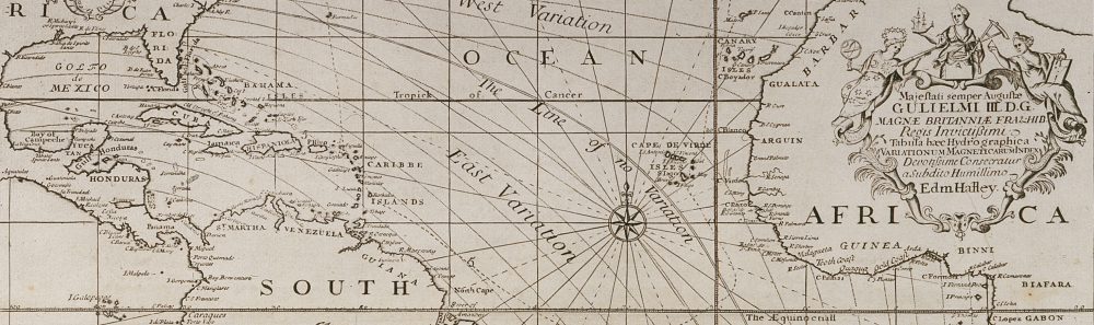
The chart – known as his Atlantic Chart – holds an important place in the history of cartography, as it is regarded as the first published chart to represent magnetic declination using what became known as isogonic lines. It was not the first time such lines had been thought of, but the earlier examples were never published and Halley is thought unlikely to have known about them. [1]

We’ll look at the chart and its data in a moment, but first I’d like to highlight some of its decorative features.

IMG_0122 copy - Version 4

To the east of the mysterious birds, we find The Icey Sea with the black-streaked “Mountains of Ice” that Halley and his crew had encountered in February (notice their track passing through it). Neither Halley nor his crew had seen icebergs before and Halley was unsure whether they were floating or grounded.

IMG_0122 copy - Version 8

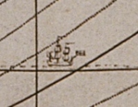
The track of Halley’s second voyage is shown on the chart and indicated by representations of the Paramore pursuing her figure-of-eight course.

IMG_0122 copy - Version 5

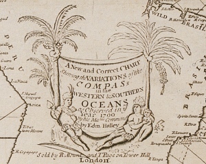
There are three cartouches on the chart: the one on South America is formed by a native family reclining beneath two fruit-laden palm trees. The adults wear feathered headdresses and skirts, the woman clutches a small child and the man holds a spear, has a bow at his feet and a quiver of arrows on his back. Behind them, hanging between the trees, is a sheet bearing the chart’s title:

A New and Correct CHART Shewing the Variations of the COMPASs in the WESTERN & SOUTHERN OCEANS as Observed in ye Year 1700 by his Ma:ties Command by Edm. Halley.

IMG_0122 copy - Version 6

A second cartouche appears on the landmass of Africa and carries the chart’s dedication to William III and is topped by personifications of astronomy (holding a telescope and armillary sphere), navigation (a backstaff and ship) and mathematics (dividers and triangle).

The third cartouche is found on North America and explains the information depicted in the chart:

The Curve Lines which are drawn over the Seas in this Chart, do shew at one View all the places where the Variation of the Compass is the same; The Numbers to them, shew how many degrees the Needle declines either Eastwards or Westwards from the true North; and the Double Line passing near Bermudas and the Cape de Virde Isles is that where the Needle stands true, without Variation.

And here’s the full chart, shown with the permission of the Royal Geographical Society:

Halley's Atlantic Chart (© Royal Geographical Society (with IBG), Image S)

Halley’s Atlantic Chart (© Royal Geographical Society (with IBG) (£), Image S0015919)

You can see that it has two compass roses, the one in the mid-Atlantic radiating lines that somewhat obscure Halley’s “Curve Lines” of equal magnetic declination. (Halley himself realised this was a problem and omitted this feature on the World Chart he published around a year later.) It is on a Mercator projection, with lines of latitude and longitude, and the meridian of London, the equator and tropics identified, but no indication of scale.

This version of the chart includes text that was written subsequently by Halley and printed in two strips that could be stuck to the sides of the original chart. It describes how to consult the chart by way of examples, and explains that it has two uses:

  • to enable the mariner to know by how much he needs to adjust his course to take account of the magnetic variation, and
  • to estimate a ship’s longitude at sea, the curve lines running nearly north-south (as off the west cost of Africa) giving “a very good Indication of the Distance of the Land” from the ship

This useful knowledge is obtained by reference to the isogonic lines. They are a little difficult to pick out but you can easily see the double curved line to the right of the central compass, which Halley has named The Line of No Variation (the agonic line) and the curved lines above and right show the degree to which the compass varies west of geographic north, and to the left, east of geographic north (the number of degrees of variation is shown on the horizontal line above The Icey Sea).

As mentioned above, the chart was (and is) regarded as the first (extant) published use of isolines (contour lines), and until the nineteenth century these lines were known as Halleyan lines.

So the chart is impressive and historically important, but how accurate was it? Alan Cook observed that it was “an improvement on anything that had gone before”, [2] but as I wrote in a previous post, the problem with longitude is knowing both where you are and where the place is that you’re heading. Halley’s recorded longitude was often inaccurate and sometimes considerably so: when he was sailing towards St Helena from the east, the longitude value he reported is actually west of the island – and so the degree of variation he thought applied to the east of the island in fact applied to the west.

Similarly the coordinates of islands and land weren’t then accurately known: Cape Horn, for example, is roughly 10° further west on Halley’s chart than we now know it to be, so his lines of variation near that coast must be likewise misplaced. [3] It seems to me that the moral of this exercise is that to devise a chart that helps estimate a ship’s longitude at sea, the deviser needs to have a fairly accurate knowledge of longitude in the first place.

But Halley was alert to the likelihood of error in his chart and in his final paragraph he wrote that:

…all knowing Mariners are desired to lend their Assistance and Informations, towards the perfecting of this useful Work. And if by undoubted Observations it be found in any Part defective, the Notes of it will be received with all grateful Acknowledgment, and the Chart corrected accordingly.

And I think that’s how Halley’s chart was most useful: it was a cartographic innovation from which better and more accurate maps might evolve.

_______________

[1] For details of prior manuscript isoline charts see Thrower, The Three Voyages of Edmond Halley in the Paramore 1698-1701 (Hakluyt Society: London, 1981) pp 57-58, and Thrower, Maps & Civilization (3rd ed, Chicago and London, 2008) pp 97-101.

[2] Cook, Edmond Halley: Charting the Heavens and the Seas (Oxford, 1998) p 281.

[3] In 1714 Halley defended his World Chart (an extended version of his Atlantic Chart, incorporating data supplied by others) in the Philosophical Transactions from charges of inaccuracy by the French Royal Academy of Sciences, including that he had placed Cape Horn too far west.

All images © Royal Geographic Society (with IBG) (£), Ref S0015919.

Halley and longitude

If you’ve been following this blog about Halley’s voyages, you’re probably aware that 2014 is the 300th anniversary of the Longitude Act, which offered financial rewards for practicable methods of finding longitude at sea to specified degrees of accuracy.

Halley was involved with the quest for longitude throughout his long life: in 1675, aged 18, he was present when Flamsteed and Hooke visited the proposed site of the new observatory in Greenwich, being built by order of Charles II to help find longitude at sea; he was made a commissioner under the 1714 Longitude Act, courtesy of his position as Savilian Professor of Geometry (later also as Astronomer Royal), and around 1730 it was Halley who sent clockmaker John Harrison to see George Graham to discuss his ideas for a marine chronometer.

By the second half of the 18th century, there were two serious contending methods for finding longitude at sea, lunar distances and timekeepers, but in the late 17th and early 18th centuries, a diverse range of schemes was proposed, including finding longitude via magnetic variation.

Magnetic variation (or declination) is the angle between magnetic and true north in a horizontal plane and was well known to the scientifically-minded, as too was the fact that it varied in different locations and also over time. It was thought that if an underlying pattern to the variation could be identified, it might offer a way of finding one’s longitude.

Halley undertook his first two voyages to measure the declination around the Atlantic in order to improve the accuracy of compass measurements, and to ascertain more accurate co-ordinates for the places he visited – but his published magnetic data also offered a means of estimating longitude at sea.

We’ll see Halley’s results in due course but for now we’ll consider one of the key difficulties with the theory, which is best illustrated by comparing data from four ships’ logs. [1]

At the start of Halley’s first voyage, he sailed from the Isle of Wight to Madeira in company with Admiral Benbow’s squadron and four of the five ships’ logs have survived, so we can compare their recorded latitude and longitude over several days:

COMPARISON OF LATITUDES AT NOON

1698 Falmouth Gloucester Lynn Paramore
Dec 2 47°28′ 47°39′ 47°24′ 47°23′
Dec 3… 46.28 46.30 46.13 46.20
Dec 14 32.39 32.36 32.43 32.25
Dec 15 32.22 32.26 32.19 32.15

Here, I’m showing the first and last two days that all four ships recorded data (leaving the English Channel and approaching Madeira) and you can see immediately that the latitudes are very similar – but the reported longitudes present a very different picture (first/last 5 days):

COMPARISON OF LONGITUDES AT NOON

1698 Falmouth Gloucester Lynn Paramore
Dec 2 149.3 8°01′ 2°10′ W 8°00′
Dec 3 60.1 6.59 3.30 9.10
Dec 4 5.53 5.12 10.03
Dec 5 29.9 5.34 6.00 10.09
Dec 6… 51′-5/10 4.27 7.07 11.07
Dec 11 8.41 W 3.00 9.35 12.15
Dec 12 8.55 W 3.00 9.39 12.15
Dec 13 10.50 1.08 11.15 14.09
Dec 14 12.03 0.14 11.42 15.03
Dec 15 13.20 13.11 16.07

This table looks like a confused jumble, demonstrating that this is a problematic coordinate. Looking first at the Paramore, Halley always noted that his longitude position was measured west from London, and on December 15 he described himself as being to the south-east of Madeira, which is 16°55′ west of London, and so 16°07′ seems a respectable figure for his position.

The Gloucester does not specify where its longitude is measured from but apparently starts from the same longitude as the Paramore but then declines in value to zero as it approaches Madeira, and so that ship’s longitude is being measured east from Madeira (or possibly El Hierro in the Canaries, a common zero meridian of the time, in which case the final value is over a degree out).

The Lynn‘s figures increase like the Paramore‘s, but the values are quite different and I think these values are measured from Lizard Point as they depart from the English Channel (it isn’t specified). The later values for the Falmouth are similar to the Lynn‘s but the earlier ones are unlike any others and I’m assuming these positions are only partially calculated and represent the minutes travelled since the previous noon.

So these logs demonstrate one of the problems with longitude: even if you could accurately measure your longitude, where did you measure it from? (The prime meridian at Greenwich wasn’t agreed upon until the 1880s.) And how did this varying data affect the accuracy of the period’s maps and charts?

In other words, Halley didn’t really know where he was (his recorded longitude is often erroneous, sometimes considerably so) or even, strictly, where he was heading as many places were wrongly laid down in maps – and so how useful could a theory be that was founded on wrongly-placed locations?

In spite of this, Halley apparently found all the islands he states he will sail for, even though some are little more than large rocks in a vast ocean. Halley followed the customary practice of parallel sailing (sailing along a coast until you attained the latitude of the place you were aiming for and then sailing east/west until you reached it) but on his “Southern cruise” he was seeking tiny islands (Tristan da Cunha, Martim Vaz) from the middle of the Atlantic ocean – I think he must have had at least one very sharp-sighted crew member on board!

IMG_0165 - Version 2

_______________

[1] References for the logs are: Falmouth NA, ADM 51/341; Gloucester NA, ADM 51/401; Lynn NA, ADM 51/3892; Paramore BL, Add MSS 30398. The figures are (mostly) degrees/minutes but the notation differs in each log (I’ve used the Paramore‘s).

Halley writes from St Helena

Before leaving St Helena, Halley sent a letter to the Admiralty – there’s no addressee but it’s presumably the Secretary, Josiah Burchett. He tells Burchett about the great danger they encountered among the “Islands of Ice” and also that he has “noe reason to doubt” that he will be able to derive a general theory of compass variation from his observations that will help mariners find their longitude at sea.

The letter isn’t in Halley’s handwriting, and I’ve made some minor changes to the punctuation and split it into two paragraphs to make it easier to read, but left the spelling as written.

(Halley to ?Burchett, dated 30 March 1700 from St Helena, National Archives ADM 1/1871)

Hono:rd Sr

I must Intreat You to lay before the Lords of the Admty this account of what I have done in execution of the Orders I Received from them. Since my last from St. Iago, which I hope came long since to Your hands, haveing not been able to fetch Madera by reason of the winds shifting upon me, I was Obleged to putt into Ryo Jennero in Brasile to gett some Rumm for my ships company, from whence I wrote you a letter which I suppose will not be in Engl[and] soe soon as this. I left Ryo Jennero on the 29° of December last and stood to the Southward till the 1st of February, when being gotten into my Station Vizt in Lattd: 52°½ and 35° west Longitude from London, we fell in with great Islands of Ice, of soe Incredible a hight and Magnitude, that I scarce dare write my thoughts of it. At first we took it for land with chaulky clifts, and the topp all covered with snow, but we soon found our mistake by standing in with it, and that it was nothing but Ice, though it could not be less then ?200 foot high, and one Island at least 5 mile in front. We could not get ground in 140 fadtham, Yet I conceive it was a ground, Ice being very little lighter then water and not above an Eight part above the Surface when it swims. It was then the hight of Summer, but we had noe other singe of it but long Days; it froze both night and day, whence it may be Understood how these bodies of Ice are generated being allways increased and never thawing.

The next day February the 2d. we were in Imminent Danger to looss our ship and lives, being Invironed with Ice on all sides in a fogg soe thick, that we could not see it till was ready to strike against it, and had it blowne hard it had scarce been possible to escape it: Soe I stood to the Northward to get clear of it, which in the Lattd. of 50° I did, and their Saw the last Ice. In my way hither I Discoverd* the Isles of Tristan da Cunha, and in Eleaven Weeks from Ryo Jennero I arrived at this Island, to fill my Water and refrezen my men, and in this whole course I have found noe reason to doubt of an exact conformity in the variations of the compass to a generall Theory, which I am in great hopes to settle effectually

I am

Honord Sr.

Your most Obedt Servt

Edmond Halley

* “Discoverd” here simply means ‘saw’

Halley’s second logbook

Halley has been sailing steadily southwards since leaving St Iago (Santiago) in the Cape Verde Islands and he arrived at Rio de Janeiro on December 14, where he’ll remain for the next two weeks. The outward section of his voyage, down to his most southerly latitude (which he’ll reach about the end of January), isn’t very eventful and so I thought this would be a suitable time to look at his second logbook, which begins with the heading:

A Journal of a Voyage in his Ma:tis Pink ye Paramore intended for the Discovery of ye Variation of the Compass kept by Edmund Halley Commander anno 1699 & 1700

(I’ve written before about the correct spelling of Halley’s first name and that of his ship.)

Like the first logbook, the second is not written by Halley but presumably by his clerk, William Curtiss, and so again the spelling and abbreviations are the clerk’s and not Halley’s. [1] The log is written on the same size (roughly 41cm high by 27cm wide) and type of paper as the first logbook and covers 53 sides (the first was 17 sides).

Unlike the first journal, the second is not signed at the end by Halley and it also differs slightly in structure. The first log included several tables of data, ranging from two days to forty-three, but the second has only two tables of eight and eleven days, and instead largely gives the data in prose, as in these two examples for 2 and 11 November 1699:

[2 Nov] By a very good observation I am in 7°.40′ North Latt: Since yesterday noon we have had the Winds from EbN to NEbE a fine gentle Gale; in the night we had much Lightning, but no Thunder. We have made our way S24°E Distance 73 Miles, Diffrence of Longitude 30′ East, My Long from Lon: 18°:57′ West

[11 Nov] By a good observation I am in Latt 2°.42′ We have had the wind mostly at SSE and have made our way good W38S. 62 Miles diffr of Long 48 Minutes Long West from Lon. 20°:37′ a Fine Gale and fair weather Saturday Morning and Evening I had a good observation of the Variation Morn Ampl[itude] 18°:50′ Even 21°:30′.

So at noon each day he records his latitude, the weather, his course, miles covered, difference of longitude from the previous day’s measurement, and his total longitude west from London. Most entries at sea include this basic information in this style, and a number of days include additional data (variation and amplitude) and anything out of the ordinary (such as birds flying around the ship).

There is no overall ‘story’ to the second voyage, unlike the first with the hostility of Lieutenant Harrison, and Harrison’s eventual court martial. Halley is now focused on collecting his data and we’ll see what use he puts it to at the end of the voyage.

One thing I find surprising (and frustrating) is that he makes very few remarks about the places he visits and appears to show little interest in the lands or native inhabitants – and this leads me to wonder whether Halley might perhaps have kept a private journal?

His second logbook is very much a ship’s log rather than a natural philosopher’s journal, but as an active member of the Royal Society I would expect him to take an interest in a wide range of subjects, with which he could entertain the Fellows on his return. [2] When Halley was at the Chester Mint, in the two years before his first voyage, he sent several reports about local events to the Society (some were published in the Philosophical Transactions), so it seems strange that he would sail around the Atlantic and not make notes of events that would be likely to interest the Fellows. [3]

I haven’t encountered any reference to a private journal, but we saw from the Society’s minutes that he collected botanical specimens on his first voyage, an activity that was not recorded in his logbook, and similarly there are unrecorded items arising from this voyage (which I’ll show at its conclusion), and so a private journal or notes might perhaps have existed – and how much more interesting they would surely be for the general reader!

But there are some entertaining entries still to come in his official logbook, which will resume on 29 December when he leaves Rio for the southern latitudes, where he and his crew will encounter something that none of them has ever seen before…

This post was first published on 23 December 2013 and revised on 15 December 2017.

_______________

[1] I have reasons to doubt that the journals of the first two voyages now in the British Library were written on the ship during the voyages. The BL versions might be neat copies written up at the end of each voyage, possibly by someone other than the ship’s clerks, although they are certainly contemporary with the voyages.

[2] Halley was elected Fellow of the Royal Society on 30 November 1678 but had to resign his fellowship when he became clerk in January 1686. He was re-elected FRS on 30 November 1700.

[3] These accounts from Chester published in the Phil Trans give some idea of the range of subjects Halley might report on: a dog born “per anum” and a Roman altar; two reports of a hailstorm here and here; a trip to Wales to try the Torricellian experiment; and observations of a lunar eclipse.

Instructions for Halley’s second voyage

Halley received his commission to be Master and Commander of Paramore on his second voyage on 23 August 1699, and his instructions for the voyage on the 12 September.

His instructions were almost identical to those he received for his first voyage, namely:

  • to measure the variations of the compass (magnetic variation)
  • to ascertain the latitude and longitude of the places he visits, particularly in the West Indies
  • to discover the unknown lands in the south Atlantic

only this time, the section on the Terra Incognita refers to finding it specifically between the latitudes of 50 and 55 degrees south, which Halley himself asked to be included in his instructions in a letter to the Admiralty.

Here are his instructions in full (remember ye/ym = the/them):

Whereas his Majesty has been pleased to lend his Pink ye Paramour, for your proceeding a second time w:th her on an Expedition to Improve ye knowledge of the Longitude & variation of ye Compass, which ship is now Compleatly mann’d, stored and victualled at his Majesty’s Charge for ye said Expedition, you are therefore hereby required and directed forthwith to proceed with her according to ye following Instructions.

You are without loss of time to Sett Saile with her, and proceed to make a Discovery of ye unknowne South lands between ye Magellan Streights & ye Cape of good hope, between ye Latt:d of 50 & 55 South, if you meete not with ye land sooner observing ye variation of ye Compass with all ye accuracy you can, as also ye True Scituation both in Longitude & Latt:d of ye ports where you arrive.

You are likewise to make ye like observations at as many of ye Islands, in ye Seas between ye aforesaid Coasts, as you can (without too much deviation) bring into your Course.

In your returne home you are to visit ye English West India Plantations, or as many of ym as conveniently you may, & in them to make such observations as may contribute to lay them downe Truly in their Geographicall Scituation, & in all ye Course of your Voyage, you must be carefull to omitt no oppertunity of noting ye variation of ye Compass, of which you are to keep a Register in your Journall.

You are for ye better lengthning out your provisions, to put ye Men under your Comand, when you come out of ye Channell, to six to four Men’s allowance assuring ym that they shall be punctually paid for ye same at ye End of ye Voyage.

You are during ye Terme of this Voyage, to be very carefull in Conforming your selfe to what is directed by ye Generall printed Instructions annexed to your Comission, with regard as well to his Majesty’s honour as to ye Governement of ye ship under your Comand; and when you returne to England, you are to call in at Plymouth, & finding no orders there to ye contrary, to make ye best of your way to ye Downes & remaine there till further order.

Cape Horn is roughly on the same latitude that Halley's headed for (via Wikipedia Commons)

Cape Horn is roughly on the same latitude that Halley’s heading for (via Wikimedia Commons)