Halley’s third logbook

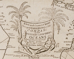
I said at the start of this Channel voyage that I wouldn’t be live-tweeting the logbook as I’d done for Halley’s two Atlantic voyages, as I felt the high proportion of technical data would be of little interest to the general reader. That was a pity as the third logbook is the only one handwritten by Halley, and so from that point of view it’s an interesting document.

In fact I did tweet a few entries at the start of the voyage and I’m doing so again now at the end as these entries contain more general information – but to give you a flavour of the main substance of the log, here’s a typical entry in which Halley records soundings and the times and lunar positions of the tides:

[Sat, June 21] about 9h in the Morn I weighd and stood off to Sea, with a gentle gale of ENE wind, and about One after noon came to an anker in 18 fath. the Ness Light baring NNW; and Calis cliff ENE. here the westward tide was done at 5h.35′, or three hours and half before the Moons Southing. whence I concluded the course of the Tides here the same as at the Ness. viz that a II½ Moon ends the Eastern Tide. at 6h I weighd and stood to the eastward with a small gale of SSW wind, and about 9h fell with the West end of the Riprapps which is a narrow rigd of soft sand. I crost it severall times in 9, 8 and 7 fath and the Eastern tide being near done, I came to an anker in that depth the Ness light baring WNW and that of the South Foreland NbE p[er] Compass. here I rode two tides and found the Eastern tide done on a SW or NE Moon nearest. that it flowed about three fath. that it runs half tide here as by the Shore and that the Sett of the Stream is nearest NE and SW.

We’ll consider the purpose of this data when we look at the results of the voyage, but in this post I want to focus on what I like to call The Mystery of Halley’s Clerks.

Now that remark may excite expectations that this post will struggle to satisfy for this is not a tale of clerks going to sea and mysteriously disappearing, but rather a puzzle about what exactly the clerks did on the voyages – why, for example, was the third logbook written up by Halley and not by his clerk?

The clerk on the third voyage was one Richard Pinfold, who was the only person besides Halley to sail on all three voyages. On the two Atlantic voyages Pinfold was listed as captain’s servant, but on the third voyage he was said to have been captain’s clerk, and so I wondered whether he might have been a servant in Halley’s own household and been promoted to clerk as a ‘reward’ for going on the first two voyages, with Halley effectively covering the job himself. However, the manuscript pay and muster books show that Pinfold was actually entered as gunner’s mate and that the post of captain’s clerk was later interposed in the pay book beneath gunner’s mate. Pinfold was paid a salary as both gunner’s mate (£5 8s 6d) and captain’s clerk (£1 12s 11d), and the small wage paid to him as clerk suggests he performed that job for only a short time, and we know he wrote neither the logbook nor Halley’s letters.

The logs of the two Atlantic voyages weren’t written up by Halley, so they must’ve been written up by his clerks… well, possibly, but possibly not. There’s no immediate reason to doubt that the log of the first voyage was written by the clerk, Caleb Harmon, but the log of the second voyage is more of a puzzle. Halley wrote all his own letters to the Admiralty on both voyages, except for two on the second, and you might expect these to have been written by the clerk, William Curtiss, but they are in a different hand from that of the logbook. My first thought was that Curtiss perhaps fell ill with the “Barbadoes desease” at the same time as Halley, and so another crew member wrote them – but the two rogue letters (which are in the same hand) were written on 30 March and 8 July, either side of the period of sickness in late May, and the July letter states specifically that “we are a very healthy ship” at present. Why then did someone else write the letters, more than three months apart, and why did that person not receive extra pay as Pinfold did on the third voyage? Or why did Curtiss write the letters but not then the logbook?

The person who wrote the first logbook isn’t straightforward either. From the start of this project I’d been surprised at how neat and uniform the logs were and wondered whether they’d actually been written during the voyage or after the ship’s return to London, but then found that other logbooks were similarly neat and so thought that clerks might make draft notes and then write them up neatly while at anchor or in calm seas.

The idea of draft notes fits with a comment made by Alexander Dalrymple in an advertisement for his 1773 publication of Halley’s two Atlantic logs that

The Journal of Dr. Halley’s first Voyage is written on sundry scraps of paper, and some parts repeated in different places, and so blended that it was a very difficult matter to make it out intelligibly…

Dalrymple, who borrowed (and seemingly failed to return) these “scraps of paper” from the Board of Longitude, doesn’t mention whether the handwriting on the scraps was Halley’s or someone else’s, which is a pity as that might tell us something about how that logbook was compiled. A further curiosity is that Dalrymple seems to have been unaware of the existence of fair copies of the two logbooks (now in the British Library), and his published version of the second log was evidently compiled from another source, as there are discrepancies between the two. So what was the source for the second log used by Dalrymple, and who wrote it? And when were the fair copies of the two journals written?

These “sundry scraps of paper” also suggest a new spin on the warning given to Halley by Josiah Burchett at the end of the second voyage. Burchett wrote to Halley in Deptford, giving him permission to leave his ship to call on their lordships in London, “only lett mee give you this Caution, To have ye Books in readinesse”. Now I’d previously assumed this warning was intended to help Halley overcome the misgivings felt by some of their lordships about his handling of the prematurely-terminated first voyage* by making sure he was properly prepared when he met them, but now I wonder if it instead implies that Halley had previously displeased their lordships by returning from that voyage with only “scraps of paper” for his journal, and only had it written up on his return.

So while I think the mysteries surrounding Halley’s clerks might not rival And Then There Were None for excitement, they certainly seem to form a Problem at Sea.

* If you didn’t follow the first voyage, click on the tag for Edward Harrison to read about Halley’s problems with Lt Harrison and other officers.

Able seamen wanted!

When Halley’s first voyage ended prematurely with his return to England to court martial his lieutenant, he had to use all his diplomatic skills to persuade the Lords of the Admiralty to allow him a second attempt. That second voyage, however, was deemed so successful that their lordships lost no time in approving his next proposal for an expedition to survey the tides of the Channel.

This proposal was dated 23 April 1701 and it was evidently approved almost immediately, as on the 26th Halley wrote again to “humbly entreat my Commission to be dispatcht, in order to gett the Paramore Pink mann’d with such Compliment [sic] as their Lopps shall think fitting”, and his commission as master and commander of the Paramore was issued that day.[1] At the same time, the Admiralty sent an order to the Navy Board to clean and fit out the Paramore for “Channell Service”, and they agreed to all the requests for “Extraordinarys” that Halley had made in his letter, including his suggestion that the crew “cannot be well less than it was last time viz: 25 Men.”[2]

Halley wanted his commission quickly so he could begin recruiting his crew, as he was concerned that seamen were scarce as “no men [were] now offering themselves as usuall at other times.” Halley’s problem was that Royal Navy wages were then lower than those offered by merchant ships: Peter Earle tells us that wages in both the royal and merchant navies were broadly similar during peacetime (about 25 shillings a month for an able seaman), but that merchant wages rose dramatically during war when the competition for men became intense.[3]

In 1701, Europe was gearing up for what we know as the War of the Spanish Succession, and so merchant wages were presumably rising in anticipation of its outbreak. In a letter dated 4 June 1701, Halley complained that “I find my self disappointed in my Mate, who for great wages has been tempted to break his promise to me”, and expressed his concern that “for 40 sh[illings] p[er] month I fear I cannot have a man capable to take charge of my shipp, Marchants [sic] giving now so much to any able Seaman” – so merchant ships were already paying able seamen at a 15 shilling premium.

Halley had great difficulty obtaining his crew, and from the date his project was approved until he set sail nearly two months later, he wrote a series of increasingly desperate letters on the subject to Josiah Burchett, Secretary to the Admiralty.

On 31 May, he asked if “their Lopps shall thinking fitting to spare me but two able Seamen out of four or five of the Ships of Warr”, promising “I will take care to return them where I had them in case the breaking out of a war oblige me to desist from my undertaking.” And in an undated letter (endorsed June), Halley wrote that the Paramore was ready to sail if only he had his complement of men, and so “I beseech you to lay before their Lopps the great difficulty I find to gett them”. On 4 June he requested “leave to have out of the Shipps of Warr, under such restriction as their Lopps please, such men as shall be willing to serve on board me”, and this prompted their lordships to order that “3 Prest Men” on ships in the Downs should be discharged into the Paramore on her arrival, which they amended a few days later to “so many Men as he Shall have occasion of”. Halley sailed from Deptford on June 14 and received four men from ships in the Downs, when he anchored there a few days later.

It’s interesting that Halley writes of men “as shall be willing to serve on board me”, as I’m not sure whether this is simply a piece of naval phraseology or a precaution against the trouble he had on his first voyage with recalcitrant officers – although I am sure that if I were a “prest” seaman, I’d rather be on a scientific cruise in the English Channel with Halley, than part of a crew in the war fleet!

The Liberty of the Subject (1779), a satirical depiction of a press-gang (Source: National Maritime Museum, ID PAG8527)

The Liberty of the Subject (1779), a satirical depiction of a press-gang. (Source: National Maritime Museum, ID PAG8527)

Finally, just to let you know that I’m not intending to tweet the log of his third voyage, as even I can see that a report of his continual anchoring around the Channel doesn’t provide a compelling read (to anyone but myself), although I will tweet the occasional entry.

I’m also in the latter stages of my MA and, alas, have little free time for this blog, but I will not neglect Captain Halley entirely and expect to publish a few short posts during his four month voyage (as well as writing my dissertation about him!).

_______________

[1] All quotes from Halley’s letters (written to Josiah Burchett) are from TNA, ADM 1/1872, and his commission is in TNA, ADM 6/6, f91v.

[2] Admiralty order to clean and fit out the Paramore is in TNA, ADM 2/181, p117.

[3] Peter Earle, Sailors: English Merchant Seamen 1650-1775 (London: Methuen, 2007), pp186-8.

The end of Halley’s second voyage

Halley arrived back in Deptford from his second voyage on 10 September 1700 and he’ll return to sea for his third voyage in June 1701 (June 2015 by the life of this blog), so I thought I’d close this phase of my project by looking at some of the things that Edmond will be doing in the intervening months.

As we’ve seen (here and here), he began preparing his chart of magnetic variation as soon as he returned to London and there are periodic entries in the Royal Society minutes of his showing (what are assumed to be) manuscript drafts of his chart at their meetings. He presented a copy formally to the Society on 4 June 1701, when the minutes record:

Mr Halley presented the Society with a Map of his late Voiage to the South. He was thanked for it, & it was order’d to be hung in the Meeting room. [1]

The exact publication date of the chart isn’t known but is assumed to have been during the second quarter of 1701 (given its presentation date to the RS), and it occurs to me that a letter dated 6 May 1701 from the Admiralty to the Navy Board, awarding a bonus of £200 to Halley on the order of the king, may have been prompted by the publication of his chart:

In obedience to his Mats. [Majesty’s] Commands signified to this Board, Wee do hereby desire and direct you to cause to be paid unto Captn. Edward [sic] Halley, out of the Money in the hands of the Trea[sure]r of the Navy upon Acct. of the Tenths of Prizes the sum of two Hundred Pounds, in consideration of his great Paines and care in a late Voyage he made for the discovering the Variation of the Needle. [2]

Halley resumed his attendance at Royal Society meetings when they reconvened after their summer recess, and, having resigned his Fellowship in 1686 to become the Society’s clerk, he was re-elected FRS at the General Meeting of 30 November 1700 and voted one of the auditors of their accounts on December 17. [3]

Halley was often referred to as “Capt Halley” in the Society’s minutes of this period, but it’s somewhat surprising how few references there are to his voyage; I assume Edmond mostly talked about his expedition in the coffeehouses.

Halley by Kneller (NMM Ref)

Halley, by Kneller (© NMM, BHC2734)

It was perhaps during this period that Halley had his portrait painted by Godfrey Kneller. The date of the portrait isn’t known, but has been estimated at around 20 years after his voyages because of a mezzotint version published after Halley became Astronomer Royal in 1720. However, Alan Cook says that Halley is wearing naval uniform and so suggests it may have been painted in 1702 after his third voyage, and this – or even 1701 – seems more likely to me, when Halley was famed for his voyages, and also because Halley appears younger in this portrait than in the one known to date before 1713. [4]

In between preparing his chart, attending Royal Society meetings, frequenting the coffeehouses, and perhaps having his portrait painted, Halley surely entertained his wife, Mary, and their three children with tales of adventures and of the people and animals he’d seen on his cruise. Perhaps he brought back curiosities as gifts for them?

I know he did bring back some items, and they’re partly what prompted me to speculate whether Halley had kept a private journal or notes during his voyage. Another reason is that one or both of his logs may initially have been written on loose pieces of paper and then written up later (and there is some doubt in my mind whether the fair copies were actually written up by his clerk(s)). I hope to do more research on the history of his logbooks and will perhaps write more about this at the end of his third voyage.

A further reason for my speculation is that there are extant papers besides his logbook surviving from the second voyage – namely, a series of sketches of fish! He presented these drawings (made by himself) to the Royal Society on 6 November 1700, along with some sketches of the Batavian Islands; the sketches of the Islands are seemingly lost but five sketches* of fish are safely stored in the Society’s archives and here’s perhaps the best of the set, with text written by Halley:

Fish (© Royal Society, Image)

“A Fish Taken in the Latitude of 36° NEbN from Bermodas following an old Mast overgrown with Barnacles.” (© Royal Society, RS.9360)

It was a great pleasure to see the originals in the Society’s library; they are more impressive ‘in the flesh’, and I particularly liked that they gave me a palpable sense of Edmond sitting down in his cabin and carefully sketching the fish on the table before him (you can really sense him at work on the fish’s scales towards the tail). The drawings may not display the talent of Hooke or Waller, but their ordinariness somehow serves to evoke the physical presence of Halley the man.

And so, having conjured his presence, we’ll leave him be for a while. His third voyage will start in June next year (2015 for us), and I’ll be back then to conclude this project to bring astronomer Edmond Halley’s seafaring adventures to wider attention.

* I couldn’t link to the page showing all the fish, so here are the individual links to the other four: Doctor fish, Tuna fish, Pilot fish, Flying fish. If only there’d been a sketch of his birds!

_______________

[1] Royal Society, JBO/10 p 219.

[2] National Archives, ADM 2/181 p125.

[3] Royal Society, JBO/10 pp 204 and 206.

[4] Cook, Edmond Halley: Charting the Heavens and the Seas (Oxford, 1998) p xv.

Halley’s Atlantic Chart, part 2: his results

Halley undertook his Atlantic voyages to measure the magnetic variation at sea. Magnetic variation (or declination) is the angle between magnetic and geographic north in a horizontal plane. Halley thought that if a pattern could be observed in the variation, it might offer a way to determine a ship’s longitude at sea. He measured the variation regularly throughout his two voyages and began preparing the presentation of his data as soon as he arrived back in Deptford in September 1700.

Halley is noted for his ability to draw general conclusions from complex data and for his appreciation of visual representation of those conclusions, and he demonstrated both these traits in presenting his data in the form of a sea chart.

The chart – known as his Atlantic Chart – holds an important place in the history of cartography, as it is regarded as the first published chart to represent magnetic declination using what became known as isogonic lines. It was not the first time such lines had been thought of, but the earlier examples were never published and Halley is thought unlikely to have known about them. [1]

We’ll look at the chart and its data in a moment, but first I’d like to highlight some of its decorative features.

IMG_0122 copy - Version 4

To the east of the mysterious birds, we find The Icey Sea with the black-streaked “Mountains of Ice” that Halley and his crew had encountered in February (notice their track passing through it). Neither Halley nor his crew had seen icebergs before and Halley was unsure whether they were floating or grounded.

IMG_0122 copy - Version 8

The track of Halley’s second voyage is shown on the chart and indicated by representations of the Paramore pursuing her figure-of-eight course.

IMG_0122 copy - Version 5

There are three cartouches on the chart: the one on South America is formed by a native family reclining beneath two fruit-laden palm trees. The adults wear feathered headdresses and skirts, the woman clutches a small child and the man holds a spear, has a bow at his feet and a quiver of arrows on his back. Behind them, hanging between the trees, is a sheet bearing the chart’s title:

A New and Correct CHART Shewing the Variations of the COMPASs in the WESTERN & SOUTHERN OCEANS as Observed in ye Year 1700 by his Ma:ties Command by Edm. Halley.

IMG_0122 copy - Version 6

A second cartouche appears on the landmass of Africa and carries the chart’s dedication to William III and is topped by personifications of astronomy (holding a telescope and armillary sphere), navigation (a backstaff and ship) and mathematics (dividers and triangle).

The third cartouche is found on North America and explains the information depicted in the chart:

The Curve Lines which are drawn over the Seas in this Chart, do shew at one View all the places where the Variation of the Compass is the same; The Numbers to them, shew how many degrees the Needle declines either Eastwards or Westwards from the true North; and the Double Line passing near Bermudas and the Cape de Virde Isles is that where the Needle stands true, without Variation.

And here’s the full chart, shown with the permission of the Royal Geographical Society:

Halley's Atlantic Chart (© Royal Geographical Society (with IBG), Image S)

Halley’s Atlantic Chart (© Royal Geographical Society (with IBG) (£), Image S0015919)

You can see that it has two compass roses, the one in the mid-Atlantic radiating lines that somewhat obscure Halley’s “Curve Lines” of equal magnetic declination. (Halley himself realised this was a problem and omitted this feature on the World Chart he published around a year later.) It is on a Mercator projection, with lines of latitude and longitude, and the meridian of London, the equator and tropics identified, but no indication of scale.

This version of the chart includes text that was written subsequently by Halley and printed in two strips that could be stuck to the sides of the original chart. It describes how to consult the chart by way of examples, and explains that it has two uses:

  • to enable the mariner to know by how much he needs to adjust his course to take account of the magnetic variation, and
  • to estimate a ship’s longitude at sea, the curve lines running nearly north-south (as off the west cost of Africa) giving “a very good Indication of the Distance of the Land” from the ship

This useful knowledge is obtained by reference to the isogonic lines. They are a little difficult to pick out but you can easily see the double curved line to the right of the central compass, which Halley has named The Line of No Variation (the agonic line) and the curved lines above and right show the degree to which the compass varies west of geographic north, and to the left, east of geographic north (the number of degrees of variation is shown on the horizontal line above The Icey Sea).

As mentioned above, the chart was (and is) regarded as the first (extant) published use of isolines (contour lines), and until the nineteenth century these lines were known as Halleyan lines.

So the chart is impressive and historically important, but how accurate was it? Alan Cook observed that it was “an improvement on anything that had gone before”, [2] but as I wrote in a previous post, the problem with longitude is knowing both where you are and where the place is that you’re heading. Halley’s recorded longitude was often inaccurate and sometimes considerably so: when he was sailing towards St Helena from the east, the longitude value he reported is actually west of the island – and so the degree of variation he thought applied to the east of the island in fact applied to the west.

Similarly the coordinates of islands and land weren’t then accurately known: Cape Horn, for example, is roughly 10° further west on Halley’s chart than we now know it to be, so his lines of variation near that coast must be likewise misplaced. [3] It seems to me that the moral of this exercise is that to devise a chart that helps estimate a ship’s longitude at sea, the deviser needs to have a fairly accurate knowledge of longitude in the first place.

But Halley was alert to the likelihood of error in his chart and in his final paragraph he wrote that:

…all knowing Mariners are desired to lend their Assistance and Informations, towards the perfecting of this useful Work. And if by undoubted Observations it be found in any Part defective, the Notes of it will be received with all grateful Acknowledgment, and the Chart corrected accordingly.

And I think that’s how Halley’s chart was most useful: it was a cartographic innovation from which better and more accurate maps might evolve.

_______________

[1] For details of prior manuscript isoline charts see Thrower, The Three Voyages of Edmond Halley in the Paramore 1698-1701 (Hakluyt Society: London, 1981) pp 57-58, and Thrower, Maps & Civilization (3rd ed, Chicago and London, 2008) pp 97-101.

[2] Cook, Edmond Halley: Charting the Heavens and the Seas (Oxford, 1998) p 281.

[3] In 1714 Halley defended his World Chart (an extended version of his Atlantic Chart, incorporating data supplied by others) in the Philosophical Transactions from charges of inaccuracy by the French Royal Academy of Sciences, including that he had placed Cape Horn too far west.

All images © Royal Geographic Society (with IBG) (£), Ref S0015919.

Halley’s Atlantic Chart, part 1: fish or fowl revisited

Over the next two posts we’ll look at the results of Halley’s voyage, which he published in the form of a sea chart. But before we consider his chart in full, I want to pick out one detail which may help to settle the identity of those mysterious creatures that Halley saw in the South Atlantic.

In a previous post we looked at Halley’s descriptions of three animals – two birds and something akin to a whale – that he’d seen in the seas to the north-west of South Georgia, and I summarised his descriptions as follows:

  1. a bird he takes to be a penguin with a black head and back, white breast, and a bill like that of a crow; it swims deep, dives on the ship’s approach, doesn’t appear to fly, and has a neck like a swan
  2. a second bird he also takes to be a penguin, larger than the first, and the colour and size of a “young Cygnett”, it has a bill that hooks downwards, cries like a bittern, and also swims deep, dives on the ship’s approach, doesn’t seem to fly, and has a neck like a swan
  3. an animal thought by the crew to be a seal but which Halley asserts is not. It bends its tail into a bow, has large fins like a shark and a head like a turtle
800px-Giant_petrel_with_chicks - Version 2

Giant petrel with chicks. (Brocken Inaglory/Wikimedia)

While researching that post, I wondered if the second bird might have been a petrel (because of the beak) and some readers suggested that too, but the main objection is that almost every image of petrels shows them flying, which Halley says they don’t do (“either not having wings, or else not commonly useing them”).

Another reader suggested they might have been shags and I think these seem more likely as they resemble penguins and have long necks (I’m looking at the Imperial and South Georgia varieties). They do fly, but the proportion of images of them flying is far lower than it is for petrels.

Phalacrocorax_atriceps_-Cooper_Bay,_South_Georgia,_British_Overseas_Territories,_UK-8

Imperial Shag, South Georgia. (Liam Quinn/Wikimedia)

In that earlier post I mentioned there was another piece of information about these birds that appears at the end of the voyage, and it appears in Halley’s chart. There, Halley gives a description of the birds and provides a little more detail:

The Sea in these parts abounds with two sorts of Animalls of a Middle Species between a Bird and a Fish, having necks like Swans and Swimming with their whole Bodyes always under water only putting up their long Necks for Air.

Now it seems to me that “a Middle Species between a Bird and a Fish” is a good way to describe penguins – but happily Halley doesn’t just describe his birds, he depicts them too! Here they are:

IMG_0122 copy - Version 3

Extract from Halley’s Atlantic Chart – notice the feet. (© Royal Geographical Society (with IBG) (£), Image S0015919)

Er… oh, well, perhaps they’re not quite my idea of penguins after all. But before I scoff too much at Halley’s illustration, it’s worth remembering that he was trying to describe something he’d never seen before and to people who likewise had never seen such animals before, and so he has to use vocabulary and comparative imagery that were familiar to him and his readers. Additionally, he wasn’t near land when he saw the birds and he hadn’t mentioned seeing any floating ice, so he may only have seen them swimming in the sea, which would have made it very difficult for him to see them properly (have a look at this 36 second film of penguins at sea and you’ll appreciate his difficulty).

If you look closely at the birds, you can see that their beaks are slightly different, and the one on the right has a few tufts on the back of its head, so I wondered if that might have been a type of crested penguin, such as a southern rockhopper?

574px-Gorfou_sauteur_-_Rockhopper_Penguin

Rockhopper Penguin. (© Samuel Blanc/Wikimedia)

As to the animal the crew thought was a seal and Halley says is not, what’s curious about that is that he doesn’t call it a whale or whale-like, an animal he would have known – perhaps he was even among the crowd that went to gawp at this poor cetacean stranded in the Thames around 1690. [1]

AN00049548_001_l

Broadside, c1690. (© British Museum, Image Z,1.163)

I don’t have any more information about this animal, which Halley’s biographers have suggested might have been a bottlenose whale, a killer whale or a dolphin, although there are problems with each of these identifications – but I have been wondering whether it might have been a Risso’s dolphin? They have a more turtle-like head, a large dorsal fin, and unlike the bottlenose and killer whale are not remarkable in size, something which Halley fails to comment on. An unfamiliar type of dolphin might also explain why Halley doesn’t use the word whale and why the crew think it’s a seal.

But there are three objections to this suggestion: there don’t seem to be many images of them “twisting [their] tayl into a bow” as Halley describes them doing, he may have been outside their range when he saw them, and the sea temperature may have been too cold.

So we haven’t resolved for certain what these creatures were but we have added some new ideas to the list of possibilities. One thing is certain, though, and that’s that no further clues are likely to come from Halley: five months after his return to England, his recollection of these animals was even more confused as we find it minuted that at the Royal Society meeting of 5 February 1701:

Mr Halley said that he saw a kind of Tortoises in the S. of Brazile, having Necks like Swans, and all their bodies under Water. [2]

And for that creature, I think we may need to search among the monsters of medieval cartography, not the seas of the South Atlantic!

UPDATE MARCH 2017: HALLEY VINDICATED!

I rather scoffed at Halley’s depiction of penguins when I wrote this post in 2014, so you’ll imagine my astonishment when I came across a photograph on Twitter that entirely vindicated Halley’s drawing. The photograph was taken by Neil Spencer (@HalleyVIDoc), a doctor based at the Halley Research Station in Antarctica, who was himself surprised to see how penguins swam, tweeting “Didn’t realise penguins swim like ducks when on the surface!” and appending the photographed that demonstrated the point. Neil kindly gave me permission to use his photo – but let’s first remind ourselves of Halley’s own depiction:

IMG_0122 copy - Version 3

Extract from Halley’s Atlantic Chart. (© Royal Geographical Society (with IBG) (£), Image S0015919)

And now here’s Neil’s photograph:

Penguins swimming in Antarctic seas, by Neil Spencer (Shown with permission)

Penguins swimming in Antarctic seas, by Neil Spencer. (Used with permission)

Separated at birth, no? And a lesson learned by me not to dismiss historical descriptions that seem rather naive and amusing (sorry, Edmond!).

If you’re not familiar with the Halley Research Station, it was set up by the Royal Society in 1956 as the British contribution to the International Geophysical Year of 1957/58, and named after Halley in recognition of his voyage to the South Atlantic, and to mark the tercentenary of his birth. Halley came within about 200 nautical miles of South Georgia on his second voyage, and South Georgia is roughly 1,300 nautical miles north of the Halley station (you can find them both on the map below). There have actually been six Halley stations on the Brunt Ice Shelf, and you can read about the history of these bases at the British Antarctic Survey (BAS) website here. The website has lots of information about the scientific work carried out at the station, along with photos of the six Halley bases, and details of the recent relocation of the current base, Halley VI. You might also enjoy (as I did) this look at the evolution of Antarctic bases from wooden huts to sci-fi chic, by the BBC (spot the tube roundel on the Halley III photo!).

Lastly, I wonder what Halley would think if he saw this map of the research stations now scattered all over Antarctica, having voyaged in search of the southern Terra Incognita just 300 years ago.

Map of Antarctic stations - Halley VI is near the coast of the Weddell Sea (Source: Teetaweepo/Wikipedia)

Map of Antarctic stations – Halley VI is near the coast of the Weddell Sea. (Source: Teetaweepo/Wikipedia)

_______________

[1] The text is well worth a read. You can probably make out the title, A Trew Draught of the Whale as he was seen at Blackwell Dock, and underneath it says:

This Monsterous Fish is 57 foot in Lenght & near 40 foot About, he is more in hight, then in breath, and is taken to be a matter of 50 Tunn in Wight, He was first discover’d near the Bouy of the Nore, Where he was fier’d at by a Kings Yoath so received sum Wound, & made toward the Shoure so came along by ye Hoop & beat himselfe upon ye Sand after that he was Harpoon’d & Taken, then Bought by a Quacor, etc.

[2] Royal Society, JBO/10 p 210.

Halley and longitude

If you’ve been following this blog about Halley’s voyages, you’re probably aware that 2014 is the 300th anniversary of the Longitude Act, which offered financial rewards for practicable methods of finding longitude at sea to specified degrees of accuracy.

Halley was involved with the quest for longitude throughout his long life: in 1675, aged 18, he was present when Flamsteed and Hooke visited the proposed site of the new observatory in Greenwich, being built by order of Charles II to help find longitude at sea; he was made a commissioner under the 1714 Longitude Act, courtesy of his position as Savilian Professor of Geometry (later also as Astronomer Royal), and around 1730 it was Halley who sent clockmaker John Harrison to see George Graham to discuss his ideas for a marine chronometer.

By the second half of the 18th century, there were two serious contending methods for finding longitude at sea, lunar distances and timekeepers, but in the late 17th and early 18th centuries, a diverse range of schemes was proposed, including finding longitude via magnetic variation.

Magnetic variation (or declination) is the angle between magnetic and true north in a horizontal plane and was well known to the scientifically-minded, as too was the fact that it varied in different locations and also over time. It was thought that if an underlying pattern to the variation could be identified, it might offer a way of finding one’s longitude.

Halley undertook his first two voyages to measure the declination around the Atlantic in order to improve the accuracy of compass measurements, and to ascertain more accurate co-ordinates for the places he visited – but his published magnetic data also offered a means of estimating longitude at sea.

We’ll see Halley’s results in due course but for now we’ll consider one of the key difficulties with the theory, which is best illustrated by comparing data from four ships’ logs. [1]

At the start of Halley’s first voyage, he sailed from the Isle of Wight to Madeira in company with Admiral Benbow’s squadron and four of the five ships’ logs have survived, so we can compare their recorded latitude and longitude over several days:

COMPARISON OF LATITUDES AT NOON

1698 Falmouth Gloucester Lynn Paramore
Dec 2 47°28′ 47°39′ 47°24′ 47°23′
Dec 3… 46.28 46.30 46.13 46.20
Dec 14 32.39 32.36 32.43 32.25
Dec 15 32.22 32.26 32.19 32.15

Here, I’m showing the first and last two days that all four ships recorded data (leaving the English Channel and approaching Madeira) and you can see immediately that the latitudes are very similar – but the reported longitudes present a very different picture (first/last 5 days):

COMPARISON OF LONGITUDES AT NOON

1698 Falmouth Gloucester Lynn Paramore
Dec 2 149.3 8°01′ 2°10′ W 8°00′
Dec 3 60.1 6.59 3.30 9.10
Dec 4 5.53 5.12 10.03
Dec 5 29.9 5.34 6.00 10.09
Dec 6… 51′-5/10 4.27 7.07 11.07
Dec 11 8.41 W 3.00 9.35 12.15
Dec 12 8.55 W 3.00 9.39 12.15
Dec 13 10.50 1.08 11.15 14.09
Dec 14 12.03 0.14 11.42 15.03
Dec 15 13.20 13.11 16.07

This table looks like a confused jumble, demonstrating that this is a problematic coordinate. Looking first at the Paramore, Halley always noted that his longitude position was measured west from London, and on December 15 he described himself as being to the south-east of Madeira, which is 16°55′ west of London, and so 16°07′ seems a respectable figure for his position.

The Gloucester does not specify where its longitude is measured from but apparently starts from the same longitude as the Paramore but then declines in value to zero as it approaches Madeira, and so that ship’s longitude is being measured east from Madeira (or possibly El Hierro in the Canaries, a common zero meridian of the time, in which case the final value is over a degree out).

The Lynn‘s figures increase like the Paramore‘s, but the values are quite different and I think these values are measured from Lizard Point as they depart from the English Channel (it isn’t specified). The later values for the Falmouth are similar to the Lynn‘s but the earlier ones are unlike any others and I’m assuming these positions are only partially calculated and represent the minutes travelled since the previous noon.

So these logs demonstrate one of the problems with longitude: even if you could accurately measure your longitude, where did you measure it from? (The prime meridian at Greenwich wasn’t agreed upon until the 1880s.) And how did this varying data affect the accuracy of the period’s maps and charts?

In other words, Halley didn’t really know where he was (his recorded longitude is often erroneous, sometimes considerably so) or even, strictly, where he was heading as many places were wrongly laid down in maps – and so how useful could a theory be that was founded on wrongly-placed locations?

In spite of this, Halley apparently found all the islands he states he will sail for, even though some are little more than large rocks in a vast ocean. Halley followed the customary practice of parallel sailing (sailing along a coast until you attained the latitude of the place you were aiming for and then sailing east/west until you reached it) but on his “Southern cruise” he was seeking tiny islands (Tristan da Cunha, Martim Vaz) from the middle of the Atlantic ocean – I think he must have had at least one very sharp-sighted crew member on board!

IMG_0165 - Version 2

_______________

[1] References for the logs are: Falmouth NA, ADM 51/341; Gloucester NA, ADM 51/401; Lynn NA, ADM 51/3892; Paramore BL, Add MSS 30398. The figures are (mostly) degrees/minutes but the notation differs in each log (I’ve used the Paramore‘s).

Halley writes from Bermuda

The Paramore anchored in St George’s Harbour, Bermuda, on Friday 21 June 1700 and Halley and his crew remained there for nearly three weeks. They were busy during that time, the crew careening the ship in order to clean her, and Halley taking the latitude and longitude of the island, observing the tides and coastal dangers, and buying a new stream anchor to replace the one they had lost at Barbados.

Bermuda, by Guiljelm Blaeuw, 1630. (© BNF Gallica, Département Cartes et Plans, GE DD-2987 (9146))

Before leaving the island on 11 July, Halley wrote an informative letter to the Admiralty in London, describing his progress during the last few months:

(Halley to ?Burchett, dated 8 July 1700 from “Bermudas”, National Archives ADM 1/1871 (not autograph))

Honourd Sr

My last from St: Hellena, gave your Honour an Account of my Southern cruise, wherin I endeavoured to see the bounds of this Ocean on that side, but in Lattd. of 52°½ was intercepted with Ice cold and foggs Scarce credible at that time of the Year. haveing spent a Month to the Southwards of 40 degrees, and Winter comeing on, I stood to the Norwards Again and fell with the three Islands of Tristan da Cunha which yeilding us noe hope of refreshment, I went to St: Helena, where the continued rains, made the water soe thick with a brackish mudd, that when it settled it was scarce fitt to be drunke; all other necesarys that Island furnishes a Bundantley. at Trinidad we found excellent good water, but nothing else. Soe here I changed as much of my St Hellena water as I could, and proceeded to Fernambouc in Brassile, being desirous to hear if all were at peace in Europe, haveing had noe sort of Advice for near eight months, here one Mr. Hardwyck that calls himselfe English consull, shewed himselfe very desirous to make prize of me, as a pyrate and kept me under a guard in his house, whilst he went A Board to examine, notwithstanding I shewed him both my commisions and the smallness of my force for such a purpose, from hence in sixteen days I arrived at Barbados on the 21st of May, where I found the Island afflicted with a Severe pestilentiall dissease, which scarce spares any one and had it been as mortall as common would in a great measure have Depeopled the Island, I staied theire but three days, yet my selfe and many of my men were seazed with it, and tho it used me gently and I was soon up again yet it cost me my skin, my ships company by the extraordenary care of my Doctor all did well of it, and at present we are a very healthy ship: to morrow I goe from hence to coast alongst the North America and hope to waite on their Lordsps: my selfe within a month after the arrivall of this, being in great hopes, that the account I bring them of the variations and other matters may appear soe much for the publick benefitt as to give their Lordsps. intire satisfaction:

I am Your Hon:rs most

Obed:t Servant:

Edmond Halley

We’ve looked before at Halley’s encounter with icebergs, his stay on St Helena and his visit to Trinidad (modern Trindade), and read how Halley himself described being environed by “Islands of Ice” in the South Atlantic, but we can look now at some additional information concerning his arrest at Pernambuco and his illness at Barbados.

During his stay at Pernambuco Halley recorded In his logbook that:

Mr. Hardwick…desired me to call on him at his house this afternoon, where instead of Business he caused me to be Arrested, and a Portuguese Guard Sett over me … and I was given to understand that Mr. Hardwick had Acted in my Affair wth.out Authority being only impower’d to Act for the Affrican Company, and the Owners of the Shipp Hanniball wch. had been seized there as a Pirate and had no Commission of Consul

This “Mr. Hardwick” was one Joseph Hardwick who held the title of vice-consul in the city of Lisbon, from where the British envoy extraordinary, Paul Methuen, had given him authority to sail to Pernambuco “in Order to the takeing posession and remitting hither whatsoever remains there belonging to the ships Hanniball and Eagle which were Seized there last year [1697] by the Governours Order”. [1]

I haven’t had time to uncover the full story of the seizure of these ships but I noticed that Hardwick was specifically warned not to exceed his written authority, and so unless that authority had been extended in the two intervening years, I think that Halley was right to object that “Mr. Hardwick had Acted in my Affair wth.out Authority”.

The pestilential disease contracted by Halley and some of his crew at Barbados has not been identified, but a gastro-intestinal illness, yellow fever, and typhoid fever have all been proposed, the latter suggested by Halley’s remark in this letter that it “cost me my skin”. It’s interesting that he says that “it used me gently and I was soon up again”, because his log entries show that he was ill for quite some time, falling ill on 24 May and remarking that his strength was returning “but Slowly” on 5 June, which sounds like a lengthy illness to me. [2]

His doctor on both voyages was George Alfrey, whom Halley seems to have known before the first voyage as he specifically requested that the Admiralty warrant Alfrey to be his “Chirurgeon”, observing that Alfrey had “served in severall of his Ma:ties shipps for some years last past.” [3] And though not a fellow of the Royal Society himself, Alfrey apparently knew some of the fellows as he was in communication (as we shall see) with Hans Sloane and James Petiver. It’s possible that Alfrey died less than three years after this voyage ended, as there’s a George Alfrey, “Chirurgeon of Woolwich”, who died in 1703. I’m not sure it’s the same man, but two surgeons named George Alfrey in a maritime location seems fairly unlikely. [4]

In any event, Halley’s belief in Alfrey’s abilities seems to have been well-judged and it’s pleasing to read that “we are a very healthy ship” as Halley and his crew prepare for the homeward passage to England.

_______________

[1] Instructions to Joseph Hardwick, dated Lisbon 7 Feb 1698, National Archives, SP 89/17 Part 2, ff273r-27v.

[2] Norman Thrower mistranscribes this as “tho it used me greatly”, but the word is definitely “gently”. See Thrower, The Three Voyages of Edmond Halley in the Paramore 1698-1701, (Hakluyt Society: London, 1980) p 308.

[3] Halley to the Lords of the Admiralty, 21 Sept 1698, TNA, ADM 106/519/365.

[4] The contents of the will of the George Alfrey who died in 1703 (TNA PROB 11/471/222) don’t settle whether he was/was not Halley’s doctor and I have some slight doubt that it’s the same man as this one may only have been 22 at the start of Halley’s first voyage, which seems rather young for a surgeon who had served for “some years last past”.