The end of Halley’s third voyage

Halley arrived back at Deptford on 10 October 1701 and immediately began to prepare his data for publication. He had undertaken the voyage with the aim of identifying a general rule for the complex tides of the Channel, and before he returned he had written to Josiah Burchett, Secretary to the Admiralty, to tell him that he had “discovered, beyond my expectation, the generall rule of the Tides in the Channell; and in many things corrected the Charts therof”.[1]

Halley had observed the tides and depths in the Channel, and surveyed the coastline and hazards, such as sandbanks and shoals. He again chose to publish his data in the form of a chart, and by mid-November he had a draught ready to show to a meeting of the Royal Society. Some time later, the chart was published by Mount & Page under the title, ‘A NEW and CORRECT CHART of the CHANNEL between ENGLAND & FRANCE: with considerable Improvements not extant in any Draughts hitherto Publish’d; shewing the Sands, shoals, depths of Water and Anchorage, with ye flowing of the Tydes, and the setting of the Current’, which left the prospective buyer in little doubt as to what he was purchasing.[2]

Western section of Halley's Channel Chart (© Royal Geographical Society with IBG (£), Image No S0015918)

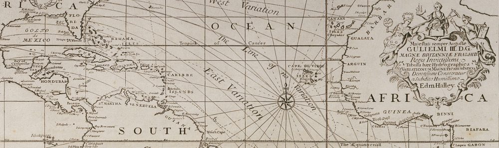
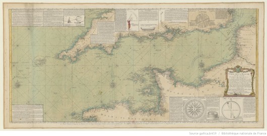
Western section of Halley’s Channel Chart (the inset maps appear on the eastern section). The original chart was probably published in 1702, and this version is no earlier than 1710, when Halley received his honorary doctorate (© Royal Geographical Society (with IBG) (£), Image No S0015918)

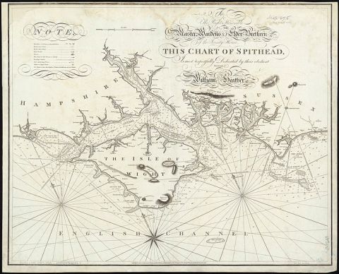
Halley’s chart resembles a portolan chart with its radiating lines, but it was an improvement on existing maps because Halley surveyed by taking angles from the rising or setting sun, rather than the more usual (but less accurate) magnetic compass. The chart has inset maps of the Isle of Wight and Plymouth Sound, and it records depths in fathoms around the Channel and ‘ye Hour of High-Water, or rather ye End of the Stream that setts to ye Eastward, on ye Day of ye New & Full Moon’ was indicated by roman numerals. Halley gave instructions to seamen on how they could use these figures to estimate the height of tides around the Channel, and he included his customary call to mariners to send him new data that could be added to future editions of the chart. The Admiralty were evidently pleased with Halley’s work as they again paid a bonus of £200 “as a reward to him for his Extraordinary pains and care he lately tooke, in observing and setting down the Ebbing, and Flowing, and setting of the Tydes in the Channell”.[3]

Manuscript version of the inset map of Plymouth Sound. The handwriting isn't Halley's hand, so was presumably made by another under his direction (@ Biblithèque Nationale de France, Image No xx)

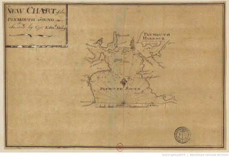
Manuscript version of the inset map of Plymouth Sound. The handwriting isn’t Halley’s, so it was presumably drawn by another under Halley’s direction (© Bibliothèque Nationale de France, Image No GESH18PF23DIV5P16D)

The chart was incorporated into pilot books and reprinted many times throughout the eighteenth century, both in England and on the continent (you can view several examples on the BNF’s Gallica website here), although Halley isn’t always credited as the source in later editions. Halley’s performance probably secured him the mission to the Adriatic, where he was sent by Queen Anne to survey the Imperial coast for the purpose of identifying a harbour where English ships could overwinter during the War of the Spanish Succession. Halley made two trips to the area in 1702 and 1703, and not only identified a suitable harbour, but also directed its fortification. Ultimately the Royal Navy did not need to overwinter in the area, but Halley’s work was rewarded by the support of the Secretary of State in the election for the Savilian Professor of Geometry at Oxford, where success brought Halley’s seafaring days to a close.

'Carte de la Manche' by the Chevalier de Beaurain 'd'Après les Observations du Scavant Capitaine Haley', 1778 (© Biblithèque National de France, Image No GESH18PF30P23)

‘Carte de la Manche’ by the Chevalier de Beaurain ‘d’Après les Observations du Scavant Capitaine Haley’, 1778. Beaurain has added a number of insets on astronomical and navigational instruments (© Bibliothèque Nationale de France, Image No GESH18PF30P23)

This final post has been horribly delayed by what Halley would call “Domestick Occasions”.

_______________

[1] TNA, ADM 1/1872, 13 Sept 1701.

[2] In fact, this may not have been the title when it was first published: I’ve looked at several versions of the chart and they all seem to have a slightly different title and it isn’t clear which one was Halley’s original.

[3] Thrower, Three Voyages of Edmond Halley, p. 345.

Paramore pink at Spithead

On 13 September 1701, Halley wrote again to Josiah Burchett, Secretary to the Admiralty, advising that he had arrived in Spithead two days earlier to “recruite” new provisions from the Victualling Office at Portsmouth, and claiming with characteristic optimism that he had succeeded in his project “beyond my expectation”.

To_the_right_honorable_the_master,_wardens_&_elder_brethren_of_the_Trinity_House,_this_chart_of_Spithead_is_..._dedicated_(8249820033)

Chart of Spithead by William Heather, 1797; Spithead is the channel north-east of the Isle of Wight (Source: Wikimedia Commons)

Paramore pink at Spithead Sept 13 1701

 Honoured Sr

These may serve to acquaint you that having observed the Course of the Tides in the Western part of the Channell, and my provision being almost spent, I came in here on the 11th Instant to recruite, and yesterday I received a months provision, with which I am going this morning to saile, to observe some particulars, which the circonstances of the Winds would not suffer me to do as I past down. I am in hopes I shall be so fortunate as to please their Lopps in this Summers Expedition, wherin I have discovered, beyond my expectation, the generall rule of the Tides in the Channell; and in many things corrected the Charts therof. Before this Months provision expires the winter season will oblige me to return, hoping from Yr Honour a favourable acceptance of the endeavours of

Honr:d Sr

Your most obedt Servt

Edm. Halley

_______________

[1] Halley to Burchett, 13 Sept 1701, TNA, ADM 1/1872

Halley writes from Dartmouth

On 23 August, Halley followed up his 29 July letter informing Burchett of his activities in the eastern part of the Channel with a report of his work in the western section. We learn that Halley continued to be hampered by the weather, but what I particularly like is that the letter provides another instance of Halley showing concern for his men by noting that the continual weighing of anchor was hard physical labour for an under-manned crew.

The south-east coast of England showing Lizard Point (red pin) and Start Point (purple), with Halley’s location at Dartmouth further along the coast at north-west.

The south-east coast of England showing Lizard Point (red pin) and Start Point (purple), with Halley’s location at Dartmouth further along the coast to the north-west.

Paramore pink at Dartmouth

Aug 23 1701

Honoured Sr

By my last of July 29 from Spitthead I gave you an account that I had carefully observed the Course of the Tides in the Eastern part of the Channell of England; Since then I have lost no opportunity, in order to do the like for the Western part, and I have ankered all along the English Coast in the Offing as far as the Lizard, and from thence inn the midd Channell, and over to Ushant, where I was the last week. The frequent weighing ankers in so deep water has been very hard service to my small company, but the greatest difficulty I find, is from the frequent gales of Wind, which, (especially without the Start) raise the Sea to that degree that there is no riding, and which, in this month of August, have forced me four severall times into Harbour. I waite here for an opportunity of smooth weather, to anker in severall places between the Start and the Sept Isles; wherby I shall be able to compleat the Sett of observations necessary to the description of the Tides in the Offing; of which I cannot find any of our books to give a tollerable account. When I return from the French coast, I entend to putt in to Spitthead, to receive any farther orders their Lopps may think proper for me. With my humble duty to their Lopps I remain

Your Honrs most obed:t servant

Edm. Halley

_______________

[1] Halley to Burchett, 23 Aug 1701, TNA, ADM 1/1872

Instructions for Halley’s third voyage

In a previous post, we read Halley’s letter to the Lords of the Admiralty proposing a new voyage to make “an exact account of the Course of the Tides on and about the Coast of England”, which he claimed would be “a work of generall Use to all Shipping”. Their lordships quickly approved his proposal, and Halley set sail on his third voyage on 14 June 1701 – but what exactly was he doing? Here’re the Admiralty’s instructions:

Whereas his Maj[es]ties Pink the Paramour, is particularly fitted out and Putt under your Command that you may proceed with her, and observe the Course of the Tydes in the Channell of England, and other things remarkable, You are therefore hereby required and directed to proceed with the Said Vessell, and use your utmost care and Diligence in observing the Course of the Tydes accordingly, as well in the Midsea as on both shores; As alsoe the Precise times of High and Low Water of the Sett and Strength of the Flood and Ebb, and how many feet it flows, in as many, and at such certaine places, as may Suffice to describe the whole. And whereas in many places in the Channell there are Irregular and halfe Tydes you are in a particular Manner to be very carefull in observing them.

And you are alsoe to take the true bearings of the Princip[a]l head Lands on the English Coast one from another, and to continue the Meridian as often as conveniently you can from side to side of the Channell, in ord[e]r to lay downe both Coast truly against one another.

And in case dureing your being employed on this Service, any other Matters may Occur unto you, the observing and Publishing whereof may tend towards the Security of the Navigation of the Subjects of his Maj[es]tie or other Princes tradeing into the Channell you are to be very carefull in the takeing notice thereof: And when you Shall have p[er]formed what Service you can, with relation to the particulars before menc[i]o[n]ed, you are to returne with the Ship you Command into the River of Thames, giving Us from time to time an Account of your Proceedings Dated this 12° June 1701 [1]

These instructions can be summarised as:

  • to make observations of the behaviour of the tides in the Channel and along the English and French coasts
  • to take bearings that will allow the French and English coasts to be correctly situated north-south from one another
  • to take note of anything else that might lead to safer navigation in the Channel for traders

The first two points were copied almost verbatim from a letter of Halley’s dated the previous day (11 June), but the third point was added by the Admiralty, and it’s been suggested that it might represent an order for Halley to gather intelligence from French waters as the two countries slid towards war. [2] That idea has been given ballast by a 1693 diary entry made by Hooke, when Halley and business partner Thomas Jett were engaged in a salvage operation, that “Hally and Jed [were] Spys”. [3]

Now I have to admit that I’m far from indifferent to this notion of Halley as a secret agent but, like Alan Cook, I’m not wholly convinced by the idea in respect to his present voyage: the Admiralty instructions clearly refer to publishing Halley’s information and they express a concern with the safety of traders of all nations operating in the Channel.

A philosophical James Bond? (© Royal Society, ID xxx)

A philosophical James Bond? (© Royal Society, Image ID RS.9284)

That said, Halley’s earlier surveying activities do seem rather surprising, for example, he was apparently surveying the Thames approaches in early 1689, during the politically-sensitive aftermath of the so-called Glorious Revolution. I’ve started to trawl through the government archives to see if I can unearth anything that indicates whether he was ever employed on intelligence work, but I’ve encountered nothing as yet – though I’ll be sure to reveal such state secrets here if I do!

_______________

[1] National Archives, ADM 2/27, pp 131-2.

[2] See Cook, Edmond Halley: Charting the Heavens and the Seas (Oxford, 1998) pp 285-6, but note that Cook refers to a published mistranscription of Hooke’s remark.

[3] Hooke, Diary, 24 March 1693, British Library, Sloane MS 4024.

Return to sea

Welcome back to Halley’s Log!

We left Captain Halley last September, newly returned to London and working on his Atlantic chart of magnetic variation, which he formally presented to the Royal Society on 4 June 1701.

But while Edmond had quickly resumed his old habits of attending Royal Society meetings and discoursing endlessly in coffeehouses, the sea was never far from his mind, and on 23 April 1701 he sent this proposal to the Lords of the Admiralty (remember “Lopps” is Halley’s abbreviation for “Lordshipps”):

It is humbly proposed

That if their Lopps shall think fitting to have an exact account of the Course of the Tides on and about the Coast of England, so taken as at one View to represent the whole; (which will be a work of generall Use to all Shipping, especially such as have occasion to turn to Windward, and wch is wanting towards the compleating the Art of Navigation) there be provided a small Vessell such as their Lopps shall think proper, with all convenient speed, on board of which such an account of the Tides may be taken, as their Lopps shall direct; for which service their Lopps most obedient servant humbly offers himself.

Edm. Halley [1]

Their Lopps did think it fitting to have the course of the tides around the southern coast of England observed and gave the order for a vessel – yes, the Paramore Pink – to be prepared for Halley’s third expedition.

So Captain Halley expects to put back to sea very very soon – there’s just the one small matter of a crew to recruit…

_______________

[1] Halley to the Lords Commissioners of the Admiralty, 23 April 1701, TNA, ADM 1/1872

The end of Halley’s second voyage

Halley arrived back in Deptford from his second voyage on 10 September 1700 and he’ll return to sea for his third voyage in June 1701 (June 2015 by the life of this blog), so I thought I’d close this phase of my project by looking at some of the things that Edmond will be doing in the intervening months.

As we’ve seen (here and here), he began preparing his chart of magnetic variation as soon as he returned to London and there are periodic entries in the Royal Society minutes of his showing (what are assumed to be) manuscript drafts of his chart at their meetings. He presented a copy formally to the Society on 4 June 1701, when the minutes record:

Mr Halley presented the Society with a Map of his late Voiage to the South. He was thanked for it, & it was order’d to be hung in the Meeting room. [1]

The exact publication date of the chart isn’t known but is assumed to have been during the second quarter of 1701 (given its presentation date to the RS), and it occurs to me that a letter dated 6 May 1701 from the Admiralty to the Navy Board, awarding a bonus of £200 to Halley on the order of the king, may have been prompted by the publication of his chart:

In obedience to his Mats. [Majesty’s] Commands signified to this Board, Wee do hereby desire and direct you to cause to be paid unto Captn. Edward [sic] Halley, out of the Money in the hands of the Trea[sure]r of the Navy upon Acct. of the Tenths of Prizes the sum of two Hundred Pounds, in consideration of his great Paines and care in a late Voyage he made for the discovering the Variation of the Needle. [2]

Halley resumed his attendance at Royal Society meetings when they reconvened after their summer recess, and, having resigned his Fellowship in 1686 to become the Society’s clerk, he was re-elected FRS at the General Meeting of 30 November 1700 and voted one of the auditors of their accounts on December 17. [3]

Halley was often referred to as “Capt Halley” in the Society’s minutes of this period, but it’s somewhat surprising how few references there are to his voyage; I assume Edmond mostly talked about his expedition in the coffeehouses.

Halley by Kneller (NMM Ref)

Halley, by Kneller (© NMM, BHC2734)

It was perhaps during this period that Halley had his portrait painted by Godfrey Kneller. The date of the portrait isn’t known, but has been estimated at around 20 years after his voyages because of a mezzotint version published after Halley became Astronomer Royal in 1720. However, Alan Cook says that Halley is wearing naval uniform and so suggests it may have been painted in 1702 after his third voyage, and this – or even 1701 – seems more likely to me, when Halley was famed for his voyages, and also because Halley appears younger in this portrait than in the one known to date before 1713. [4]

In between preparing his chart, attending Royal Society meetings, frequenting the coffeehouses, and perhaps having his portrait painted, Halley surely entertained his wife, Mary, and their three children with tales of adventures and of the people and animals he’d seen on his cruise. Perhaps he brought back curiosities as gifts for them?

I know he did bring back some items, and they’re partly what prompted me to speculate whether Halley had kept a private journal or notes during his voyage. Another reason is that one or both of his logs may initially have been written on loose pieces of paper and then written up later (and there is some doubt in my mind whether the fair copies were actually written up by his clerk(s)). I hope to do more research on the history of his logbooks and will perhaps write more about this at the end of his third voyage.

A further reason for my speculation is that there are extant papers besides his logbook surviving from the second voyage – namely, a series of sketches of fish! He presented these drawings (made by himself) to the Royal Society on 6 November 1700, along with some sketches of the Batavian Islands; the sketches of the Islands are seemingly lost but five sketches* of fish are safely stored in the Society’s archives and here’s perhaps the best of the set, with text written by Halley:

Fish (© Royal Society, Image)

“A Fish Taken in the Latitude of 36° NEbN from Bermodas following an old Mast overgrown with Barnacles.” (© Royal Society, RS.9360)

It was a great pleasure to see the originals in the Society’s library; they are more impressive ‘in the flesh’, and I particularly liked that they gave me a palpable sense of Edmond sitting down in his cabin and carefully sketching the fish on the table before him (you can really sense him at work on the fish’s scales towards the tail). The drawings may not display the talent of Hooke or Waller, but their ordinariness somehow serves to evoke the physical presence of Halley the man.

And so, having conjured his presence, we’ll leave him be for a while. His third voyage will start in June next year (2015 for us), and I’ll be back then to conclude this project to bring astronomer Edmond Halley’s seafaring adventures to wider attention.

* I couldn’t link to the page showing all the fish, so here are the individual links to the other four: Doctor fish, Tuna fish, Pilot fish, Flying fish. If only there’d been a sketch of his birds!

_______________

[1] Royal Society, JBO/10 p 219.

[2] National Archives, ADM 2/181 p125.

[3] Royal Society, JBO/10 pp 204 and 206.

[4] Cook, Edmond Halley: Charting the Heavens and the Seas (Oxford, 1998) p xv.

Halley’s Atlantic Chart, part 2: his results

Halley undertook his Atlantic voyages to measure the magnetic variation at sea. Magnetic variation (or declination) is the angle between magnetic and geographic north in a horizontal plane. Halley thought that if a pattern could be observed in the variation, it might offer a way to determine a ship’s longitude at sea. He measured the variation regularly throughout his two voyages and began preparing the presentation of his data as soon as he arrived back in Deptford in September 1700.

Halley is noted for his ability to draw general conclusions from complex data and for his appreciation of visual representation of those conclusions, and he demonstrated both these traits in presenting his data in the form of a sea chart.

The chart – known as his Atlantic Chart – holds an important place in the history of cartography, as it is regarded as the first published chart to represent magnetic declination using what became known as isogonic lines. It was not the first time such lines had been thought of, but the earlier examples were never published and Halley is thought unlikely to have known about them. [1]

We’ll look at the chart and its data in a moment, but first I’d like to highlight some of its decorative features.

IMG_0122 copy - Version 4

To the east of the mysterious birds, we find The Icey Sea with the black-streaked “Mountains of Ice” that Halley and his crew had encountered in February (notice their track passing through it). Neither Halley nor his crew had seen icebergs before and Halley was unsure whether they were floating or grounded.

IMG_0122 copy - Version 8

The track of Halley’s second voyage is shown on the chart and indicated by representations of the Paramore pursuing her figure-of-eight course.

IMG_0122 copy - Version 5

There are three cartouches on the chart: the one on South America is formed by a native family reclining beneath two fruit-laden palm trees. The adults wear feathered headdresses and skirts, the woman clutches a small child and the man holds a spear, has a bow at his feet and a quiver of arrows on his back. Behind them, hanging between the trees, is a sheet bearing the chart’s title:

A New and Correct CHART Shewing the Variations of the COMPASs in the WESTERN & SOUTHERN OCEANS as Observed in ye Year 1700 by his Ma:ties Command by Edm. Halley.

IMG_0122 copy - Version 6

A second cartouche appears on the landmass of Africa and carries the chart’s dedication to William III and is topped by personifications of astronomy (holding a telescope and armillary sphere), navigation (a backstaff and ship) and mathematics (dividers and triangle).

The third cartouche is found on North America and explains the information depicted in the chart:

The Curve Lines which are drawn over the Seas in this Chart, do shew at one View all the places where the Variation of the Compass is the same; The Numbers to them, shew how many degrees the Needle declines either Eastwards or Westwards from the true North; and the Double Line passing near Bermudas and the Cape de Virde Isles is that where the Needle stands true, without Variation.

And here’s the full chart, shown with the permission of the Royal Geographical Society:

Halley's Atlantic Chart (© Royal Geographical Society (with IBG), Image S)

Halley’s Atlantic Chart (© Royal Geographical Society (with IBG) (£), Image S0015919)

You can see that it has two compass roses, the one in the mid-Atlantic radiating lines that somewhat obscure Halley’s “Curve Lines” of equal magnetic declination. (Halley himself realised this was a problem and omitted this feature on the World Chart he published around a year later.) It is on a Mercator projection, with lines of latitude and longitude, and the meridian of London, the equator and tropics identified, but no indication of scale.

This version of the chart includes text that was written subsequently by Halley and printed in two strips that could be stuck to the sides of the original chart. It describes how to consult the chart by way of examples, and explains that it has two uses:

  • to enable the mariner to know by how much he needs to adjust his course to take account of the magnetic variation, and
  • to estimate a ship’s longitude at sea, the curve lines running nearly north-south (as off the west cost of Africa) giving “a very good Indication of the Distance of the Land” from the ship

This useful knowledge is obtained by reference to the isogonic lines. They are a little difficult to pick out but you can easily see the double curved line to the right of the central compass, which Halley has named The Line of No Variation (the agonic line) and the curved lines above and right show the degree to which the compass varies west of geographic north, and to the left, east of geographic north (the number of degrees of variation is shown on the horizontal line above The Icey Sea).

As mentioned above, the chart was (and is) regarded as the first (extant) published use of isolines (contour lines), and until the nineteenth century these lines were known as Halleyan lines.

So the chart is impressive and historically important, but how accurate was it? Alan Cook observed that it was “an improvement on anything that had gone before”, [2] but as I wrote in a previous post, the problem with longitude is knowing both where you are and where the place is that you’re heading. Halley’s recorded longitude was often inaccurate and sometimes considerably so: when he was sailing towards St Helena from the east, the longitude value he reported is actually west of the island – and so the degree of variation he thought applied to the east of the island in fact applied to the west.

Similarly the coordinates of islands and land weren’t then accurately known: Cape Horn, for example, is roughly 10° further west on Halley’s chart than we now know it to be, so his lines of variation near that coast must be likewise misplaced. [3] It seems to me that the moral of this exercise is that to devise a chart that helps estimate a ship’s longitude at sea, the deviser needs to have a fairly accurate knowledge of longitude in the first place.

But Halley was alert to the likelihood of error in his chart and in his final paragraph he wrote that:

…all knowing Mariners are desired to lend their Assistance and Informations, towards the perfecting of this useful Work. And if by undoubted Observations it be found in any Part defective, the Notes of it will be received with all grateful Acknowledgment, and the Chart corrected accordingly.

And I think that’s how Halley’s chart was most useful: it was a cartographic innovation from which better and more accurate maps might evolve.

_______________

[1] For details of prior manuscript isoline charts see Thrower, The Three Voyages of Edmond Halley in the Paramore 1698-1701 (Hakluyt Society: London, 1981) pp 57-58, and Thrower, Maps & Civilization (3rd ed, Chicago and London, 2008) pp 97-101.

[2] Cook, Edmond Halley: Charting the Heavens and the Seas (Oxford, 1998) p 281.

[3] In 1714 Halley defended his World Chart (an extended version of his Atlantic Chart, incorporating data supplied by others) in the Philosophical Transactions from charges of inaccuracy by the French Royal Academy of Sciences, including that he had placed Cape Horn too far west.

All images © Royal Geographic Society (with IBG) (£), Ref S0015919.