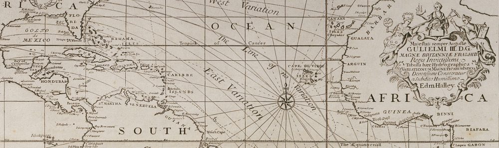
If you’ve been following this blog about Halley’s voyages, you’re probably aware that 2014 is the 300th anniversary of the Longitude Act, which offered financial rewards for practicable methods of finding longitude at sea to specified degrees of accuracy.
Halley was involved with the quest for longitude throughout his long life: in 1675, aged 18, he was present when Flamsteed and Hooke visited the proposed site of the new observatory in Greenwich, being built by order of Charles II to help find longitude at sea; he was made a commissioner under the 1714 Longitude Act, courtesy of his position as Savilian Professor of Geometry (later also as Astronomer Royal), and around 1730 it was Halley who sent clockmaker John Harrison to see George Graham to discuss his ideas for a marine chronometer.
By the second half of the 18th century, there were two serious contending methods for finding longitude at sea, lunar distances and timekeepers, but in the late 17th and early 18th centuries, a diverse range of schemes was proposed, including finding longitude via magnetic variation.
Magnetic variation (or declination) is the angle between magnetic and true north in a horizontal plane and was well known to the scientifically-minded, as too was the fact that it varied in different locations and also over time. It was thought that if an underlying pattern to the variation could be identified, it might offer a way of finding one’s longitude.
Halley undertook his first two voyages to measure the declination around the Atlantic in order to improve the accuracy of compass measurements, and to ascertain more accurate co-ordinates for the places he visited – but his published magnetic data also offered a means of estimating longitude at sea.
We’ll see Halley’s results in due course but for now we’ll consider one of the key difficulties with the theory, which is best illustrated by comparing data from four ships’ logs. [1]
At the start of Halley’s first voyage, he sailed from the Isle of Wight to Madeira in company with Admiral Benbow’s squadron and four of the five ships’ logs have survived, so we can compare their recorded latitude and longitude over several days:
|
COMPARISON OF LATITUDES AT NOON |
||||
| 1698 | Falmouth | Gloucester | Lynn | Paramore |
| Dec 2 | 47°28′ | 47°39′ | 47°24′ | 47°23′ |
| Dec 3… | 46.28 | 46.30 | 46.13 | 46.20 |
| Dec 14 | 32.39 | 32.36 | 32.43 | 32.25 |
| Dec 15 | 32.22 | 32.26 | 32.19 | 32.15 |
Here, I’m showing the first and last two days that all four ships recorded data (leaving the English Channel and approaching Madeira) and you can see immediately that the latitudes are very similar – but the reported longitudes present a very different picture (first/last 5 days):
|
COMPARISON OF LONGITUDES AT NOON |
||||
| 1698 | Falmouth | Gloucester | Lynn | Paramore |
| Dec 2 | 149.3 | 8°01′ | 2°10′ W | 8°00′ |
| Dec 3 | 60.1 | 6.59 | 3.30 | 9.10 |
| Dec 4 | – | 5.53 | 5.12 | 10.03 |
| Dec 5 | 29.9 | 5.34 | 6.00 | 10.09 |
| Dec 6… | 51′-5/10 | 4.27 | 7.07 | 11.07 |
| Dec 11 | 8.41 W | 3.00 | 9.35 | 12.15 |
| Dec 12 | 8.55 W | 3.00 | 9.39 | 12.15 |
| Dec 13 | 10.50 | 1.08 | 11.15 | 14.09 |
| Dec 14 | 12.03 | 0.14 | 11.42 | 15.03 |
| Dec 15 | 13.20 | – | 13.11 | 16.07 |
This table looks like a confused jumble, demonstrating that this is a problematic coordinate. Looking first at the Paramore, Halley always noted that his longitude position was measured west from London, and on December 15 he described himself as being to the south-east of Madeira, which is 16°55′ west of London, and so 16°07′ seems a respectable figure for his position.
The Gloucester does not specify where its longitude is measured from but apparently starts from the same longitude as the Paramore but then declines in value to zero as it approaches Madeira, and so that ship’s longitude is being measured east from Madeira (or possibly El Hierro in the Canaries, a common zero meridian of the time, in which case the final value is over a degree out).
The Lynn‘s figures increase like the Paramore‘s, but the values are quite different and I think these values are measured from Lizard Point as they depart from the English Channel (it isn’t specified). The later values for the Falmouth are similar to the Lynn‘s but the earlier ones are unlike any others and I’m assuming these positions are only partially calculated and represent the minutes travelled since the previous noon.
So these logs demonstrate one of the problems with longitude: even if you could accurately measure your longitude, where did you measure it from? (The prime meridian at Greenwich wasn’t agreed upon until the 1880s.) And how did this varying data affect the accuracy of the period’s maps and charts?
In other words, Halley didn’t really know where he was (his recorded longitude is often erroneous, sometimes considerably so) or even, strictly, where he was heading as many places were wrongly laid down in maps – and so how useful could a theory be that was founded on wrongly-placed locations?
In spite of this, Halley apparently found all the islands he states he will sail for, even though some are little more than large rocks in a vast ocean. Halley followed the customary practice of parallel sailing (sailing along a coast until you attained the latitude of the place you were aiming for and then sailing east/west until you reached it) but on his “Southern cruise” he was seeking tiny islands (Tristan da Cunha, Martim Vaz) from the middle of the Atlantic ocean – I think he must have had at least one very sharp-sighted crew member on board!

_______________
[1] References for the logs are: Falmouth NA, ADM 51/341; Gloucester NA, ADM 51/401; Lynn NA, ADM 51/3892; Paramore BL, Add MSS 30398. The figures are (mostly) degrees/minutes but the notation differs in each log (I’ve used the Paramore‘s).

Pingback: Whewell’s Gazette: Vol. 9 | Whewell's Ghost
Pingback: Whewell’s Gazette: Vol. 10 | Whewell's Ghost
Pingback: History Carnival #137 | Early Modern Medicine
Pingback: History A'la Carte 10-23-14 - Random Bits of Fascination