Back in the Thames

On 2 October, Halley wrote a short letter to Josiah Burchett, advising that he had arrived back in the Thames and requesting permission to come up to London to give the Lords of the Admiralty a report of his Channel voyage.

In the next post – which will probably appear in November* – we’ll conclude the third voyage by looking at Halley’s results. 

Paramore Pink in Long reach

Octob 2. 1701

Honoured Sr

Finding the season of the year too far lapsed to ride at anchor in the Channell; in persuance of their Lopps orders, I came into the River of Thames last night, and am at present moored in this place, where I waite their Lopps farther pleasure, hoping they please to allow me the Liberty to waite on them to render them an account of my Summers Expedition.

I am

Your Honours most obed:t Serv:t

Edm: Halley

River_Thames_Reaches

C19 image of Thames reaches from the sea to Woolwich (Source: Wikimedia Commons)

* Postscript: In fact, the concluding post for this voyage will probably be delayed until after I’ve finished my dissertation in January as I’m very pressed for time at present.

_______________

[1] Halley to Burchett, 2 Oct 1701, TNA, ADM 1/1872

Paramore pink at Spithead

On 13 September 1701, Halley wrote again to Josiah Burchett, Secretary to the Admiralty, advising that he had arrived in Spithead two days earlier to “recruite” new provisions from the Victualling Office at Portsmouth, and claiming with characteristic optimism that he had succeeded in his project “beyond my expectation”.

To_the_right_honorable_the_master,_wardens_&_elder_brethren_of_the_Trinity_House,_this_chart_of_Spithead_is_..._dedicated_(8249820033)

Chart of Spithead by William Heather, 1797; Spithead is the channel north-east of the Isle of Wight (Source: Wikimedia Commons)

Paramore pink at Spithead Sept 13 1701

 Honoured Sr

These may serve to acquaint you that having observed the Course of the Tides in the Western part of the Channell, and my provision being almost spent, I came in here on the 11th Instant to recruite, and yesterday I received a months provision, with which I am going this morning to saile, to observe some particulars, which the circonstances of the Winds would not suffer me to do as I past down. I am in hopes I shall be so fortunate as to please their Lopps in this Summers Expedition, wherin I have discovered, beyond my expectation, the generall rule of the Tides in the Channell; and in many things corrected the Charts therof. Before this Months provision expires the winter season will oblige me to return, hoping from Yr Honour a favourable acceptance of the endeavours of

Honr:d Sr

Your most obedt Servt

Edm. Halley

_______________

[1] Halley to Burchett, 13 Sept 1701, TNA, ADM 1/1872

Halley writes from Dartmouth

On 23 August, Halley followed up his 29 July letter informing Burchett of his activities in the eastern part of the Channel with a report of his work in the western section. We learn that Halley continued to be hampered by the weather, but what I particularly like is that the letter provides another instance of Halley showing concern for his men by noting that the continual weighing of anchor was hard physical labour for an under-manned crew.

The south-east coast of England showing Lizard Point (red pin) and Start Point (purple), with Halley’s location at Dartmouth further along the coast at north-west.

The south-east coast of England showing Lizard Point (red pin) and Start Point (purple), with Halley’s location at Dartmouth further along the coast to the north-west.

Paramore pink at Dartmouth

Aug 23 1701

Honoured Sr

By my last of July 29 from Spitthead I gave you an account that I had carefully observed the Course of the Tides in the Eastern part of the Channell of England; Since then I have lost no opportunity, in order to do the like for the Western part, and I have ankered all along the English Coast in the Offing as far as the Lizard, and from thence inn the midd Channell, and over to Ushant, where I was the last week. The frequent weighing ankers in so deep water has been very hard service to my small company, but the greatest difficulty I find, is from the frequent gales of Wind, which, (especially without the Start) raise the Sea to that degree that there is no riding, and which, in this month of August, have forced me four severall times into Harbour. I waite here for an opportunity of smooth weather, to anker in severall places between the Start and the Sept Isles; wherby I shall be able to compleat the Sett of observations necessary to the description of the Tides in the Offing; of which I cannot find any of our books to give a tollerable account. When I return from the French coast, I entend to putt in to Spitthead, to receive any farther orders their Lopps may think proper for me. With my humble duty to their Lopps I remain

Your Honrs most obed:t servant

Edm. Halley

_______________

[1] Halley to Burchett, 23 Aug 1701, TNA, ADM 1/1872

Halley writes from Spithead

Alas, I’ve been obliged to neglect Captain Halley recently, as I’m horribly behind with work for my MA. I had intended to write a post on the Instructions given to him by the Admiralty before I published this letter, but I’m afraid that post will have to wait – although I hope Halley’s letter, sent from Spithead, will still be of interest to readers.

As usual, the letter’s addressed to Josiah Burchett, Secretary to the Admiralty, and in it, Halley informs Burchett of his proceedings to date and his progress (when weather permits!) in taking an account of the tides in the Channel. The “Warr” he refers to is the imminent War of the Spanish Succession.

Ships at Spithead, 1797 (Source: Wikimedia Commons, NMM ID )

Ships at Spithead 1797 (Source: Wikimedia Commons, NMM ID PAJ2308)

Spitt head July 29 1701

Honoured Sr

In obedience to their Lopps orders, I have since I left the Downs on the 19th of June, endeavoured to gett as exact an account of the Tides in the Channell as possible, and have ankered all over it, from the Forland to Portland, and from Blackness to the Casketts on the French side: and I have been particularly curious in this part between the Isle of Wight and Portland and the French Coast against it, where I find the Course of the Tides very extraordinary, but which I think I can describe effectually. I have been of late putt from my business by hard gales of Wind which drove me in hither, but still hope by the end of the Summer to give their Lopps a full account of the whole Channell, if not interrupted by the breaking out of Warr, which I find is suddainly expected here. If their Lopps have any further orders for me, I shall call in at Plymouth for them, designing to saile hence as this day [sic], and to tide it down, if the weather permitt it.

I am

Your Honours most obedt servt

Edm. Halley

_______________

[1] Halley to Burchett, 29 July 1701, TNA, ADM 1/1872

Halley writes from the Downs

As we saw in my last post, Halley had a lot of trouble recruiting his complement of 25 men and by the morning of 14 June his crew numbered just 15 men, and it was only the arrival of a further four that enabled him to sail from Deptford that afternoon.

He arrived in the Downs on 16 June and two days later he sent a short letter to Josiah Burchett, Secretary to the Admiralty, advising him of his arrival and that he expected to receive the four men that their lordships had ordered to be discharged to him during that night.

This brought his crew to 23 men, which included Halley, his surgeon (a man Halley had specifically requested), his clerk*, a cook (one Thomas Cook, natch), and five servants. Let’s hope that the cook – the only time someone was so-designated on any of Halley’s voyages – kept the regular seamen well-fed!

Halley refers to his sailing instructions in his letter, and we’ll take a look at those in my next post.

Downs June 18 1701 [1]

Hon:red Sr

I arrived in the Downs on Monday last, and have to day gotten an order from the Admirall for the four men their Lopps have appointed me here; They will be delivered me this night, and with them I shall be enabled to proceed according to their Lopps Instructions designing to sayle to morrow morning. I shall not fayle to give your Hon:r an account of my proceedings as occasion shall offer being

Your Hon:rs most obed:t Servt

Edm. Halley 

Extract (written by Halley) from the Muster Book showing the four men entering Halley's service on June 19. (TNA, ADM )

Extract (in Halley’s hand) from the Paramore‘s Muster Book showing the four men (20-23) entering Halley’s service on June 19 in the Downs. (TNA (£), ADM 36/2386)

* It’s debatable whether anyone served as his clerk, as we’ll see in a future post.

_______________

[1] Halley to Burchett, 18 June 1701, TNA, ADM 1/1872

Halley’s Atlantic Chart, part 2: his results

Halley undertook his Atlantic voyages to measure the magnetic variation at sea. Magnetic variation (or declination) is the angle between magnetic and geographic north in a horizontal plane. Halley thought that if a pattern could be observed in the variation, it might offer a way to determine a ship’s longitude at sea. He measured the variation regularly throughout his two voyages and began preparing the presentation of his data as soon as he arrived back in Deptford in September 1700.

Halley is noted for his ability to draw general conclusions from complex data and for his appreciation of visual representation of those conclusions, and he demonstrated both these traits in presenting his data in the form of a sea chart.

The chart – known as his Atlantic Chart – holds an important place in the history of cartography, as it is regarded as the first published chart to represent magnetic declination using what became known as isogonic lines. It was not the first time such lines had been thought of, but the earlier examples were never published and Halley is thought unlikely to have known about them. [1]

We’ll look at the chart and its data in a moment, but first I’d like to highlight some of its decorative features.

IMG_0122 copy - Version 4

To the east of the mysterious birds, we find The Icey Sea with the black-streaked “Mountains of Ice” that Halley and his crew had encountered in February (notice their track passing through it). Neither Halley nor his crew had seen icebergs before and Halley was unsure whether they were floating or grounded.

IMG_0122 copy - Version 8

The track of Halley’s second voyage is shown on the chart and indicated by representations of the Paramore pursuing her figure-of-eight course.

IMG_0122 copy - Version 5

There are three cartouches on the chart: the one on South America is formed by a native family reclining beneath two fruit-laden palm trees. The adults wear feathered headdresses and skirts, the woman clutches a small child and the man holds a spear, has a bow at his feet and a quiver of arrows on his back. Behind them, hanging between the trees, is a sheet bearing the chart’s title:

A New and Correct CHART Shewing the Variations of the COMPASs in the WESTERN & SOUTHERN OCEANS as Observed in ye Year 1700 by his Ma:ties Command by Edm. Halley.

IMG_0122 copy - Version 6

A second cartouche appears on the landmass of Africa and carries the chart’s dedication to William III and is topped by personifications of astronomy (holding a telescope and armillary sphere), navigation (a backstaff and ship) and mathematics (dividers and triangle).

The third cartouche is found on North America and explains the information depicted in the chart:

The Curve Lines which are drawn over the Seas in this Chart, do shew at one View all the places where the Variation of the Compass is the same; The Numbers to them, shew how many degrees the Needle declines either Eastwards or Westwards from the true North; and the Double Line passing near Bermudas and the Cape de Virde Isles is that where the Needle stands true, without Variation.

And here’s the full chart, shown with the permission of the Royal Geographical Society:

Halley's Atlantic Chart (© Royal Geographical Society (with IBG), Image S)

Halley’s Atlantic Chart (© Royal Geographical Society (with IBG) (£), Image S0015919)

You can see that it has two compass roses, the one in the mid-Atlantic radiating lines that somewhat obscure Halley’s “Curve Lines” of equal magnetic declination. (Halley himself realised this was a problem and omitted this feature on the World Chart he published around a year later.) It is on a Mercator projection, with lines of latitude and longitude, and the meridian of London, the equator and tropics identified, but no indication of scale.

This version of the chart includes text that was written subsequently by Halley and printed in two strips that could be stuck to the sides of the original chart. It describes how to consult the chart by way of examples, and explains that it has two uses:

  • to enable the mariner to know by how much he needs to adjust his course to take account of the magnetic variation, and
  • to estimate a ship’s longitude at sea, the curve lines running nearly north-south (as off the west cost of Africa) giving “a very good Indication of the Distance of the Land” from the ship

This useful knowledge is obtained by reference to the isogonic lines. They are a little difficult to pick out but you can easily see the double curved line to the right of the central compass, which Halley has named The Line of No Variation (the agonic line) and the curved lines above and right show the degree to which the compass varies west of geographic north, and to the left, east of geographic north (the number of degrees of variation is shown on the horizontal line above The Icey Sea).

As mentioned above, the chart was (and is) regarded as the first (extant) published use of isolines (contour lines), and until the nineteenth century these lines were known as Halleyan lines.

So the chart is impressive and historically important, but how accurate was it? Alan Cook observed that it was “an improvement on anything that had gone before”, [2] but as I wrote in a previous post, the problem with longitude is knowing both where you are and where the place is that you’re heading. Halley’s recorded longitude was often inaccurate and sometimes considerably so: when he was sailing towards St Helena from the east, the longitude value he reported is actually west of the island – and so the degree of variation he thought applied to the east of the island in fact applied to the west.

Similarly the coordinates of islands and land weren’t then accurately known: Cape Horn, for example, is roughly 10° further west on Halley’s chart than we now know it to be, so his lines of variation near that coast must be likewise misplaced. [3] It seems to me that the moral of this exercise is that to devise a chart that helps estimate a ship’s longitude at sea, the deviser needs to have a fairly accurate knowledge of longitude in the first place.

But Halley was alert to the likelihood of error in his chart and in his final paragraph he wrote that:

…all knowing Mariners are desired to lend their Assistance and Informations, towards the perfecting of this useful Work. And if by undoubted Observations it be found in any Part defective, the Notes of it will be received with all grateful Acknowledgment, and the Chart corrected accordingly.

And I think that’s how Halley’s chart was most useful: it was a cartographic innovation from which better and more accurate maps might evolve.

_______________

[1] For details of prior manuscript isoline charts see Thrower, The Three Voyages of Edmond Halley in the Paramore 1698-1701 (Hakluyt Society: London, 1981) pp 57-58, and Thrower, Maps & Civilization (3rd ed, Chicago and London, 2008) pp 97-101.

[2] Cook, Edmond Halley: Charting the Heavens and the Seas (Oxford, 1998) p 281.

[3] In 1714 Halley defended his World Chart (an extended version of his Atlantic Chart, incorporating data supplied by others) in the Philosophical Transactions from charges of inaccuracy by the French Royal Academy of Sciences, including that he had placed Cape Horn too far west.

All images © Royal Geographic Society (with IBG) (£), Ref S0015919.

Halley’s Atlantic Chart, part 1: fish or fowl revisited

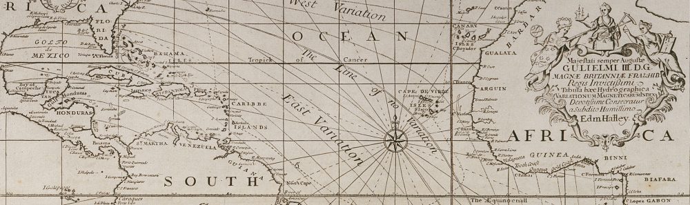
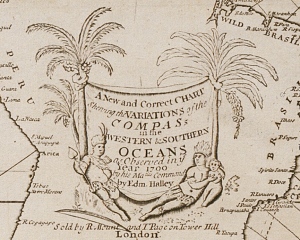
Over the next two posts we’ll look at the results of Halley’s voyage, which he published in the form of a sea chart. But before we consider his chart in full, I want to pick out one detail which may help to settle the identity of those mysterious creatures that Halley saw in the South Atlantic.

In a previous post we looked at Halley’s descriptions of three animals – two birds and something akin to a whale – that he’d seen in the seas to the north-west of South Georgia, and I summarised his descriptions as follows:

  1. a bird he takes to be a penguin with a black head and back, white breast, and a bill like that of a crow; it swims deep, dives on the ship’s approach, doesn’t appear to fly, and has a neck like a swan
  2. a second bird he also takes to be a penguin, larger than the first, and the colour and size of a “young Cygnett”, it has a bill that hooks downwards, cries like a bittern, and also swims deep, dives on the ship’s approach, doesn’t seem to fly, and has a neck like a swan
  3. an animal thought by the crew to be a seal but which Halley asserts is not. It bends its tail into a bow, has large fins like a shark and a head like a turtle
800px-Giant_petrel_with_chicks - Version 2

Giant petrel with chicks. (Brocken Inaglory/Wikimedia)

While researching that post, I wondered if the second bird might have been a petrel (because of the beak) and some readers suggested that too, but the main objection is that almost every image of petrels shows them flying, which Halley says they don’t do (“either not having wings, or else not commonly useing them”).

Another reader suggested they might have been shags and I think these seem more likely as they resemble penguins and have long necks (I’m looking at the Imperial and South Georgia varieties). They do fly, but the proportion of images of them flying is far lower than it is for petrels.

Phalacrocorax_atriceps_-Cooper_Bay,_South_Georgia,_British_Overseas_Territories,_UK-8

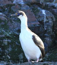
Imperial Shag, South Georgia. (Liam Quinn/Wikimedia)

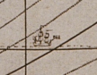
In that earlier post I mentioned there was another piece of information about these birds that appears at the end of the voyage, and it appears in Halley’s chart. There, Halley gives a description of the birds and provides a little more detail:

The Sea in these parts abounds with two sorts of Animalls of a Middle Species between a Bird and a Fish, having necks like Swans and Swimming with their whole Bodyes always under water only putting up their long Necks for Air.

Now it seems to me that “a Middle Species between a Bird and a Fish” is a good way to describe penguins – but happily Halley doesn’t just describe his birds, he depicts them too! Here they are:

IMG_0122 copy - Version 3

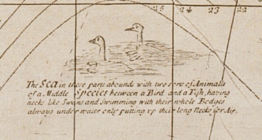
Extract from Halley’s Atlantic Chart – notice the feet. (© Royal Geographical Society (with IBG) (£), Image S0015919)

Er… oh, well, perhaps they’re not quite my idea of penguins after all. But before I scoff too much at Halley’s illustration, it’s worth remembering that he was trying to describe something he’d never seen before and to people who likewise had never seen such animals before, and so he has to use vocabulary and comparative imagery that were familiar to him and his readers. Additionally, he wasn’t near land when he saw the birds and he hadn’t mentioned seeing any floating ice, so he may only have seen them swimming in the sea, which would have made it very difficult for him to see them properly (have a look at this 36 second film of penguins at sea and you’ll appreciate his difficulty).

If you look closely at the birds, you can see that their beaks are slightly different, and the one on the right has a few tufts on the back of its head, so I wondered if that might have been a type of crested penguin, such as a southern rockhopper?

574px-Gorfou_sauteur_-_Rockhopper_Penguin

Rockhopper Penguin. (© Samuel Blanc/Wikimedia)

As to the animal the crew thought was a seal and Halley says is not, what’s curious about that is that he doesn’t call it a whale or whale-like, an animal he would have known – perhaps he was even among the crowd that went to gawp at this poor cetacean stranded in the Thames around 1690. [1]

AN00049548_001_l

Broadside, c1690. (© British Museum, Image Z,1.163)

I don’t have any more information about this animal, which Halley’s biographers have suggested might have been a bottlenose whale, a killer whale or a dolphin, although there are problems with each of these identifications – but I have been wondering whether it might have been a Risso’s dolphin? They have a more turtle-like head, a large dorsal fin, and unlike the bottlenose and killer whale are not remarkable in size, something which Halley fails to comment on. An unfamiliar type of dolphin might also explain why Halley doesn’t use the word whale and why the crew think it’s a seal.

But there are three objections to this suggestion: there don’t seem to be many images of them “twisting [their] tayl into a bow” as Halley describes them doing, he may have been outside their range when he saw them, and the sea temperature may have been too cold.

So we haven’t resolved for certain what these creatures were but we have added some new ideas to the list of possibilities. One thing is certain, though, and that’s that no further clues are likely to come from Halley: five months after his return to England, his recollection of these animals was even more confused as we find it minuted that at the Royal Society meeting of 5 February 1701:

Mr Halley said that he saw a kind of Tortoises in the S. of Brazile, having Necks like Swans, and all their bodies under Water. [2]

And for that creature, I think we may need to search among the monsters of medieval cartography, not the seas of the South Atlantic!

UPDATE MARCH 2017: HALLEY VINDICATED!

I rather scoffed at Halley’s depiction of penguins when I wrote this post in 2014, so you’ll imagine my astonishment when I came across a photograph on Twitter that entirely vindicated Halley’s drawing. The photograph was taken by Neil Spencer (@HalleyVIDoc), a doctor based at the Halley Research Station in Antarctica, who was himself surprised to see how penguins swam, tweeting “Didn’t realise penguins swim like ducks when on the surface!” and appending the photographed that demonstrated the point. Neil kindly gave me permission to use his photo – but let’s first remind ourselves of Halley’s own depiction:

IMG_0122 copy - Version 3

Extract from Halley’s Atlantic Chart. (© Royal Geographical Society (with IBG) (£), Image S0015919)

And now here’s Neil’s photograph:

Penguins swimming in Antarctic seas, by Neil Spencer (Shown with permission)

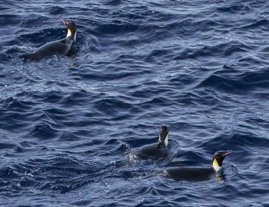
Penguins swimming in Antarctic seas, by Neil Spencer. (Used with permission)

Separated at birth, no? And a lesson learned by me not to dismiss historical descriptions that seem rather naive and amusing (sorry, Edmond!).

If you’re not familiar with the Halley Research Station, it was set up by the Royal Society in 1956 as the British contribution to the International Geophysical Year of 1957/58, and named after Halley in recognition of his voyage to the South Atlantic, and to mark the tercentenary of his birth. Halley came within about 200 nautical miles of South Georgia on his second voyage, and South Georgia is roughly 1,300 nautical miles north of the Halley station (you can find them both on the map below). There have actually been six Halley stations on the Brunt Ice Shelf, and you can read about the history of these bases at the British Antarctic Survey (BAS) website here. The website has lots of information about the scientific work carried out at the station, along with photos of the six Halley bases, and details of the recent relocation of the current base, Halley VI. You might also enjoy (as I did) this look at the evolution of Antarctic bases from wooden huts to sci-fi chic, by the BBC (spot the tube roundel on the Halley III photo!).

Lastly, I wonder what Halley would think if he saw this map of the research stations now scattered all over Antarctica, having voyaged in search of the southern Terra Incognita just 300 years ago.

Map of Antarctic stations - Halley VI is near the coast of the Weddell Sea (Source: Teetaweepo/Wikipedia)

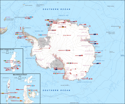
Map of Antarctic stations – Halley VI is near the coast of the Weddell Sea. (Source: Teetaweepo/Wikipedia)

_______________

[1] The text is well worth a read. You can probably make out the title, A Trew Draught of the Whale as he was seen at Blackwell Dock, and underneath it says:

This Monsterous Fish is 57 foot in Lenght & near 40 foot About, he is more in hight, then in breath, and is taken to be a matter of 50 Tunn in Wight, He was first discover’d near the Bouy of the Nore, Where he was fier’d at by a Kings Yoath so received sum Wound, & made toward the Shoure so came along by ye Hoop & beat himselfe upon ye Sand after that he was Harpoon’d & Taken, then Bought by a Quacor, etc.

[2] Royal Society, JBO/10 p 210.