Paramore pink at Spithead

On 13 September 1701, Halley wrote again to Josiah Burchett, Secretary to the Admiralty, advising that he had arrived in Spithead two days earlier to “recruite” new provisions from the Victualling Office at Portsmouth, and claiming with characteristic optimism that he had succeeded in his project “beyond my expectation”.

To_the_right_honorable_the_master,_wardens_&_elder_brethren_of_the_Trinity_House,_this_chart_of_Spithead_is_..._dedicated_(8249820033)

Chart of Spithead by William Heather, 1797; Spithead is the channel north-east of the Isle of Wight (Source: Wikimedia Commons)

Paramore pink at Spithead Sept 13 1701

 Honoured Sr

These may serve to acquaint you that having observed the Course of the Tides in the Western part of the Channell, and my provision being almost spent, I came in here on the 11th Instant to recruite, and yesterday I received a months provision, with which I am going this morning to saile, to observe some particulars, which the circonstances of the Winds would not suffer me to do as I past down. I am in hopes I shall be so fortunate as to please their Lopps in this Summers Expedition, wherin I have discovered, beyond my expectation, the generall rule of the Tides in the Channell; and in many things corrected the Charts therof. Before this Months provision expires the winter season will oblige me to return, hoping from Yr Honour a favourable acceptance of the endeavours of

Honr:d Sr

Your most obedt Servt

Edm. Halley

_______________

[1] Halley to Burchett, 13 Sept 1701, TNA, ADM 1/1872

Halley writes from Dartmouth

On 23 August, Halley followed up his 29 July letter informing Burchett of his activities in the eastern part of the Channel with a report of his work in the western section. We learn that Halley continued to be hampered by the weather, but what I particularly like is that the letter provides another instance of Halley showing concern for his men by noting that the continual weighing of anchor was hard physical labour for an under-manned crew.

The south-east coast of England showing Lizard Point (red pin) and Start Point (purple), with Halley’s location at Dartmouth further along the coast at north-west.

The south-east coast of England showing Lizard Point (red pin) and Start Point (purple), with Halley’s location at Dartmouth further along the coast to the north-west.

Paramore pink at Dartmouth

Aug 23 1701

Honoured Sr

By my last of July 29 from Spitthead I gave you an account that I had carefully observed the Course of the Tides in the Eastern part of the Channell of England; Since then I have lost no opportunity, in order to do the like for the Western part, and I have ankered all along the English Coast in the Offing as far as the Lizard, and from thence inn the midd Channell, and over to Ushant, where I was the last week. The frequent weighing ankers in so deep water has been very hard service to my small company, but the greatest difficulty I find, is from the frequent gales of Wind, which, (especially without the Start) raise the Sea to that degree that there is no riding, and which, in this month of August, have forced me four severall times into Harbour. I waite here for an opportunity of smooth weather, to anker in severall places between the Start and the Sept Isles; wherby I shall be able to compleat the Sett of observations necessary to the description of the Tides in the Offing; of which I cannot find any of our books to give a tollerable account. When I return from the French coast, I entend to putt in to Spitthead, to receive any farther orders their Lopps may think proper for me. With my humble duty to their Lopps I remain

Your Honrs most obed:t servant

Edm. Halley

_______________

[1] Halley to Burchett, 23 Aug 1701, TNA, ADM 1/1872

Halley’s Atlantic Chart, part 2: his results

Halley undertook his Atlantic voyages to measure the magnetic variation at sea. Magnetic variation (or declination) is the angle between magnetic and geographic north in a horizontal plane. Halley thought that if a pattern could be observed in the variation, it might offer a way to determine a ship’s longitude at sea. He measured the variation regularly throughout his two voyages and began preparing the presentation of his data as soon as he arrived back in Deptford in September 1700.

Halley is noted for his ability to draw general conclusions from complex data and for his appreciation of visual representation of those conclusions, and he demonstrated both these traits in presenting his data in the form of a sea chart.

The chart – known as his Atlantic Chart – holds an important place in the history of cartography, as it is regarded as the first published chart to represent magnetic declination using what became known as isogonic lines. It was not the first time such lines had been thought of, but the earlier examples were never published and Halley is thought unlikely to have known about them. [1]

We’ll look at the chart and its data in a moment, but first I’d like to highlight some of its decorative features.

IMG_0122 copy - Version 4

To the east of the mysterious birds, we find The Icey Sea with the black-streaked “Mountains of Ice” that Halley and his crew had encountered in February (notice their track passing through it). Neither Halley nor his crew had seen icebergs before and Halley was unsure whether they were floating or grounded.

IMG_0122 copy - Version 8

The track of Halley’s second voyage is shown on the chart and indicated by representations of the Paramore pursuing her figure-of-eight course.

IMG_0122 copy - Version 5

There are three cartouches on the chart: the one on South America is formed by a native family reclining beneath two fruit-laden palm trees. The adults wear feathered headdresses and skirts, the woman clutches a small child and the man holds a spear, has a bow at his feet and a quiver of arrows on his back. Behind them, hanging between the trees, is a sheet bearing the chart’s title:

A New and Correct CHART Shewing the Variations of the COMPASs in the WESTERN & SOUTHERN OCEANS as Observed in ye Year 1700 by his Ma:ties Command by Edm. Halley.

IMG_0122 copy - Version 6

A second cartouche appears on the landmass of Africa and carries the chart’s dedication to William III and is topped by personifications of astronomy (holding a telescope and armillary sphere), navigation (a backstaff and ship) and mathematics (dividers and triangle).

The third cartouche is found on North America and explains the information depicted in the chart:

The Curve Lines which are drawn over the Seas in this Chart, do shew at one View all the places where the Variation of the Compass is the same; The Numbers to them, shew how many degrees the Needle declines either Eastwards or Westwards from the true North; and the Double Line passing near Bermudas and the Cape de Virde Isles is that where the Needle stands true, without Variation.

And here’s the full chart, shown with the permission of the Royal Geographical Society:

Halley's Atlantic Chart (© Royal Geographical Society (with IBG), Image S)

Halley’s Atlantic Chart (© Royal Geographical Society (with IBG) (£), Image S0015919)

You can see that it has two compass roses, the one in the mid-Atlantic radiating lines that somewhat obscure Halley’s “Curve Lines” of equal magnetic declination. (Halley himself realised this was a problem and omitted this feature on the World Chart he published around a year later.) It is on a Mercator projection, with lines of latitude and longitude, and the meridian of London, the equator and tropics identified, but no indication of scale.

This version of the chart includes text that was written subsequently by Halley and printed in two strips that could be stuck to the sides of the original chart. It describes how to consult the chart by way of examples, and explains that it has two uses:

  • to enable the mariner to know by how much he needs to adjust his course to take account of the magnetic variation, and
  • to estimate a ship’s longitude at sea, the curve lines running nearly north-south (as off the west cost of Africa) giving “a very good Indication of the Distance of the Land” from the ship

This useful knowledge is obtained by reference to the isogonic lines. They are a little difficult to pick out but you can easily see the double curved line to the right of the central compass, which Halley has named The Line of No Variation (the agonic line) and the curved lines above and right show the degree to which the compass varies west of geographic north, and to the left, east of geographic north (the number of degrees of variation is shown on the horizontal line above The Icey Sea).

As mentioned above, the chart was (and is) regarded as the first (extant) published use of isolines (contour lines), and until the nineteenth century these lines were known as Halleyan lines.

So the chart is impressive and historically important, but how accurate was it? Alan Cook observed that it was “an improvement on anything that had gone before”, [2] but as I wrote in a previous post, the problem with longitude is knowing both where you are and where the place is that you’re heading. Halley’s recorded longitude was often inaccurate and sometimes considerably so: when he was sailing towards St Helena from the east, the longitude value he reported is actually west of the island – and so the degree of variation he thought applied to the east of the island in fact applied to the west.

Similarly the coordinates of islands and land weren’t then accurately known: Cape Horn, for example, is roughly 10° further west on Halley’s chart than we now know it to be, so his lines of variation near that coast must be likewise misplaced. [3] It seems to me that the moral of this exercise is that to devise a chart that helps estimate a ship’s longitude at sea, the deviser needs to have a fairly accurate knowledge of longitude in the first place.

But Halley was alert to the likelihood of error in his chart and in his final paragraph he wrote that:

…all knowing Mariners are desired to lend their Assistance and Informations, towards the perfecting of this useful Work. And if by undoubted Observations it be found in any Part defective, the Notes of it will be received with all grateful Acknowledgment, and the Chart corrected accordingly.

And I think that’s how Halley’s chart was most useful: it was a cartographic innovation from which better and more accurate maps might evolve.

_______________

[1] For details of prior manuscript isoline charts see Thrower, The Three Voyages of Edmond Halley in the Paramore 1698-1701 (Hakluyt Society: London, 1981) pp 57-58, and Thrower, Maps & Civilization (3rd ed, Chicago and London, 2008) pp 97-101.

[2] Cook, Edmond Halley: Charting the Heavens and the Seas (Oxford, 1998) p 281.

[3] In 1714 Halley defended his World Chart (an extended version of his Atlantic Chart, incorporating data supplied by others) in the Philosophical Transactions from charges of inaccuracy by the French Royal Academy of Sciences, including that he had placed Cape Horn too far west.

All images © Royal Geographic Society (with IBG) (£), Ref S0015919.

Halley writes from Bermuda

The Paramore anchored in St George’s Harbour, Bermuda, on Friday 21 June 1700 and Halley and his crew remained there for nearly three weeks. They were busy during that time, the crew careening the ship in order to clean her, and Halley taking the latitude and longitude of the island, observing the tides and coastal dangers, and buying a new stream anchor to replace the one they had lost at Barbados.

Bermuda, by Guiljelm Blaeuw, 1630. (© BNF Gallica, Département Cartes et Plans, GE DD-2987 (9146))

Before leaving the island on 11 July, Halley wrote an informative letter to the Admiralty in London, describing his progress during the last few months:

(Halley to ?Burchett, dated 8 July 1700 from “Bermudas”, National Archives ADM 1/1871 (not autograph))

Honourd Sr

My last from St: Hellena, gave your Honour an Account of my Southern cruise, wherin I endeavoured to see the bounds of this Ocean on that side, but in Lattd. of 52°½ was intercepted with Ice cold and foggs Scarce credible at that time of the Year. haveing spent a Month to the Southwards of 40 degrees, and Winter comeing on, I stood to the Norwards Again and fell with the three Islands of Tristan da Cunha which yeilding us noe hope of refreshment, I went to St: Helena, where the continued rains, made the water soe thick with a brackish mudd, that when it settled it was scarce fitt to be drunke; all other necesarys that Island furnishes a Bundantley. at Trinidad we found excellent good water, but nothing else. Soe here I changed as much of my St Hellena water as I could, and proceeded to Fernambouc in Brassile, being desirous to hear if all were at peace in Europe, haveing had noe sort of Advice for near eight months, here one Mr. Hardwyck that calls himselfe English consull, shewed himselfe very desirous to make prize of me, as a pyrate and kept me under a guard in his house, whilst he went A Board to examine, notwithstanding I shewed him both my commisions and the smallness of my force for such a purpose, from hence in sixteen days I arrived at Barbados on the 21st of May, where I found the Island afflicted with a Severe pestilentiall dissease, which scarce spares any one and had it been as mortall as common would in a great measure have Depeopled the Island, I staied theire but three days, yet my selfe and many of my men were seazed with it, and tho it used me gently and I was soon up again yet it cost me my skin, my ships company by the extraordenary care of my Doctor all did well of it, and at present we are a very healthy ship: to morrow I goe from hence to coast alongst the North America and hope to waite on their Lordsps: my selfe within a month after the arrivall of this, being in great hopes, that the account I bring them of the variations and other matters may appear soe much for the publick benefitt as to give their Lordsps. intire satisfaction:

I am Your Hon:rs most

Obed:t Servant:

Edmond Halley

We’ve looked before at Halley’s encounter with icebergs, his stay on St Helena and his visit to Trinidad (modern Trindade), and read how Halley himself described being environed by “Islands of Ice” in the South Atlantic, but we can look now at some additional information concerning his arrest at Pernambuco and his illness at Barbados.

During his stay at Pernambuco Halley recorded In his logbook that:

Mr. Hardwick…desired me to call on him at his house this afternoon, where instead of Business he caused me to be Arrested, and a Portuguese Guard Sett over me … and I was given to understand that Mr. Hardwick had Acted in my Affair wth.out Authority being only impower’d to Act for the Affrican Company, and the Owners of the Shipp Hanniball wch. had been seized there as a Pirate and had no Commission of Consul

This “Mr. Hardwick” was one Joseph Hardwick who held the title of vice-consul in the city of Lisbon, from where the British envoy extraordinary, Paul Methuen, had given him authority to sail to Pernambuco “in Order to the takeing posession and remitting hither whatsoever remains there belonging to the ships Hanniball and Eagle which were Seized there last year [1697] by the Governours Order”. [1]

I haven’t had time to uncover the full story of the seizure of these ships but I noticed that Hardwick was specifically warned not to exceed his written authority, and so unless that authority had been extended in the two intervening years, I think that Halley was right to object that “Mr. Hardwick had Acted in my Affair wth.out Authority”.

The pestilential disease contracted by Halley and some of his crew at Barbados has not been identified, but a gastro-intestinal illness, yellow fever, and typhoid fever have all been proposed, the latter suggested by Halley’s remark in this letter that it “cost me my skin”. It’s interesting that he says that “it used me gently and I was soon up again”, because his log entries show that he was ill for quite some time, falling ill on 24 May and remarking that his strength was returning “but Slowly” on 5 June, which sounds like a lengthy illness to me. [2]

His doctor on both voyages was George Alfrey, whom Halley seems to have known before the first voyage as he specifically requested that the Admiralty warrant Alfrey to be his “Chirurgeon”, observing that Alfrey had “served in severall of his Ma:ties shipps for some years last past.” [3] And though not a fellow of the Royal Society himself, Alfrey apparently knew some of the fellows as he was in communication (as we shall see) with Hans Sloane and James Petiver. It’s possible that Alfrey died less than three years after this voyage ended, as there’s a George Alfrey, “Chirurgeon of Woolwich”, who died in 1703. I’m not sure it’s the same man, but two surgeons named George Alfrey in a maritime location seems fairly unlikely. [4]

In any event, Halley’s belief in Alfrey’s abilities seems to have been well-judged and it’s pleasing to read that “we are a very healthy ship” as Halley and his crew prepare for the homeward passage to England.

_______________

[1] Instructions to Joseph Hardwick, dated Lisbon 7 Feb 1698, National Archives, SP 89/17 Part 2, ff273r-27v.

[2] Norman Thrower mistranscribes this as “tho it used me greatly”, but the word is definitely “gently”. See Thrower, The Three Voyages of Edmond Halley in the Paramore 1698-1701, (Hakluyt Society: London, 1980) p 308.

[3] Halley to the Lords of the Admiralty, 21 Sept 1698, TNA, ADM 106/519/365.

[4] The contents of the will of the George Alfrey who died in 1703 (TNA PROB 11/471/222) don’t settle whether he was/was not Halley’s doctor and I have some slight doubt that it’s the same man as this one may only have been 22 at the start of Halley’s first voyage, which seems rather young for a surgeon who had served for “some years last past”.

Halley writes from St Helena

Before leaving St Helena, Halley sent a letter to the Admiralty – there’s no addressee but it’s presumably the Secretary, Josiah Burchett. He tells Burchett about the great danger they encountered among the “Islands of Ice” and also that he has “noe reason to doubt” that he will be able to derive a general theory of compass variation from his observations that will help mariners find their longitude at sea.

The letter isn’t in Halley’s handwriting, and I’ve made some minor changes to the punctuation and split it into two paragraphs to make it easier to read, but left the spelling as written.

(Halley to ?Burchett, dated 30 March 1700 from St Helena, National Archives ADM 1/1871)

Hono:rd Sr

I must Intreat You to lay before the Lords of the Admty this account of what I have done in execution of the Orders I Received from them. Since my last from St. Iago, which I hope came long since to Your hands, haveing not been able to fetch Madera by reason of the winds shifting upon me, I was Obleged to putt into Ryo Jennero in Brasile to gett some Rumm for my ships company, from whence I wrote you a letter which I suppose will not be in Engl[and] soe soon as this. I left Ryo Jennero on the 29° of December last and stood to the Southward till the 1st of February, when being gotten into my Station Vizt in Lattd: 52°½ and 35° west Longitude from London, we fell in with great Islands of Ice, of soe Incredible a hight and Magnitude, that I scarce dare write my thoughts of it. At first we took it for land with chaulky clifts, and the topp all covered with snow, but we soon found our mistake by standing in with it, and that it was nothing but Ice, though it could not be less then ?200 foot high, and one Island at least 5 mile in front. We could not get ground in 140 fadtham, Yet I conceive it was a ground, Ice being very little lighter then water and not above an Eight part above the Surface when it swims. It was then the hight of Summer, but we had noe other singe of it but long Days; it froze both night and day, whence it may be Understood how these bodies of Ice are generated being allways increased and never thawing.

The next day February the 2d. we were in Imminent Danger to looss our ship and lives, being Invironed with Ice on all sides in a fogg soe thick, that we could not see it till was ready to strike against it, and had it blowne hard it had scarce been possible to escape it: Soe I stood to the Northward to get clear of it, which in the Lattd. of 50° I did, and their Saw the last Ice. In my way hither I Discoverd* the Isles of Tristan da Cunha, and in Eleaven Weeks from Ryo Jennero I arrived at this Island, to fill my Water and refrezen my men, and in this whole course I have found noe reason to doubt of an exact conformity in the variations of the compass to a generall Theory, which I am in great hopes to settle effectually

I am

Honord Sr.

Your most Obedt Servt

Edmond Halley

* “Discoverd” here simply means ‘saw’

Return to St Helena

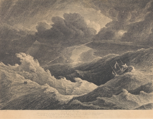
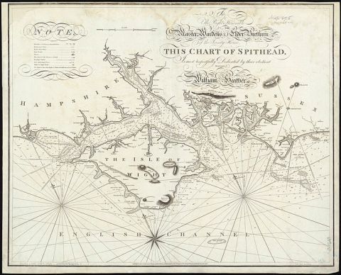
We last saw Halley encountering a storm as he sailed from Tristan da Cunha towards the Cape of Good Hope. A few days later he found the storm had blown him northwards of the Cape, and as his water supplies were low and he didn’t want to delay his voyage by heading back south, he decided to sail on to St Helena, arriving in Jamestown harbour on 12 March 1700.

Town_of_St_James,_Island_of_St_Helena_(1794)

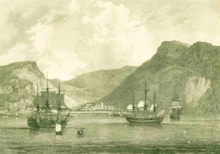
Town of St James, Island of St Helena, 1794 (Wikimedia Commons)

I’ve mentioned before that one of the most disappointing aspects of Halley’s logbook is that he records very few observations about the places and peoples he encounters, and nowhere is this more frustrating than during his visit to St Helena – for this is not Halley’s first trip to the island, it was here that he acquired a Europe-wide reputation at the age of 22.

Halley was a nineteen-year-old undergraduate at Oxford when in July 1676 he sat down to write a letter to the Royal Society’s Secretary, Henry Oldenburg. He and Oldenburg had been corresponding about a paper that would be Halley’s first appearance in the Philosophical Transactions and after some remarks about his paper, he asks if Oldenburg knows whether a work then in the press at Paris would contain a catalogue of the southern stars because:

if that work be yet undone, I have some thoughts to undertake it my self, and go to St Helena… by the next East Indie fleet, and to carry with me, large and accurate Instruments, sufficient to make a good cataloge of those starrs, and to compleat the Celestiall globe… I will willingly adventure my self, upon this enterprize, if I find the proposition acceptable, and that the East Indie company will cause me to be kindly used there, which is all I desire as to my self, and if I can have any consideracon for one to assist me; this Sr I propose to you desireing your advice as to what inconveniences there may be, and if you think my design may meet with sutable encouragement. [1]

The young and ambitious Halley was concerned that with Flamsteed, Hevelius and Cassini all at work on star catalogues, there would be no room for him to make his mark, and so he decided to travel to the southern hemisphere to map the stars that were not visible from Europe and which had so far received little attention from astronomers.

His design did meet with “sutable encouragement” and through the influence of his patrons, Sir Jonas Moore and Sir Joseph Williamson, a letter was sent from the king to the East India Company requesting that they give free passage to Halley and his friend James Clerk on their next ship to St Helena, which at that time was under the Company’s governance.

Halley left Oxford without taking his degree, and he and Clerk sailed from England around Edmond’s 20th birthday on board the East Indiaman, Unity, arriving at St Helena by early February 1677. Halley tells us he took a newly made sextant, a new pendulum clock, an old quadrant, and several telescopes including his 24 footer, and on arrival he and Clerk began building a basic observatory from which to deploy them. [2]

But matters didn’t progress quite as Halley planned, owing to the continually adverse weather. In November 1677 Halley wrote to Jonas Moore that:

such hath been my ill fortune, that the Horizon of this Island is almost always covered with a Cloud, which sometimes for some weeks together hath hid the Stars from us, and when it is clear, is of so small continuance, that we cannot take any number of Observations at once; so that now, when I expected to be returning, I have not finished above half my intended work; and almost despair to accomplish what you ought to expect from me. [3]

Oh dear, he’d travelled a long way to be thwarted by cloud-cover, but Halley wasn’t the type to be easily defeated and so to simplify the process and maximise the number of star positions he could observe, he based his own measurements on reference stars from Tycho Brahe’s catalogue, so that if Tycho’s star places (taken before the advent of telescopes) were rendered more accurate in the future, his own positions could be accordingly adjusted.

By the time he and Clerk left the island in March 1678 on board the Golden Fleece, Halley had observed 341 stars, as well as a lunar and a solar eclipse, and a transit of Mercury – and by the autumn he’d produced a catalogue of his results (published the following year), which was the first to feature observations made using telescopic sights. [4] Halley also produced a planisphere – possibly engraved by his companion, Clerk – in which he outlined a new constellation Robur Carolinum (Charles’s Oak), named to mark the occasion when King Charles had hid in an oak tree after his defeat at the Battle of Worcester.

The right ascensions and declinations of the principal fixed stars in both hemispheres to year 1678

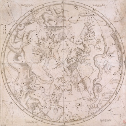
Halley’s planisphere of the southern stars. Robur Carolinum is right of centre below the Centaur’s hooves (© NMM, Image B4225). The work was engraved by a James Clerk, possibly the friend who accompanied Halley.

The catalogue and planisphere were well-received, with Flamsteed dubbing Halley “our Southern Tycho”, and Halley was rewarded with an MA by royal mandate, election to the Royal Society, and the esteem of Europe’s foremost astronomers. [5]

* * * * *

Now Halley is back on St Helena, scene of his youthful adventure. What went through his mind as he sailed into Jamestown harbour? Did he enquire after his former acquaintances? Go in search of the observatory built with his friend over 20 years earlier? Did he reflect on the path his life had taken since that first visit? He gives us no hint whatsoever, he tells us only that it rained heavily. Plus ça change.

If anyone from St Helena can advise whether Halley’s Mount is pronounced ‘Hawley’ or ‘Hallee’, please let me know via the comments. Thank you!

_______________

[1] Halley to Oldenburg, 8 July 1676, Royal Society EL/H3/38.

[2] The location of Halley’s observatory isn’t certain but there is a monument set up on what is thought the likely site on a ridge known as Halley’s Mount. You can see the monument here and the wider view here (the walls are probably from a later construction).

[3] Halley to Moore, 22 November 1677, in MacPike, Correspondence and Papers of Edmond Halley (London, 1937), pp 39-41.

[4] Halley, Catalogus Stellarum Australium (London, 1679); it was subtitled (in Latin) Supplement to the Tychonic Catalogue. The transit of Mercury on 28 October 1677 gave Halley the idea (subsequent to James Gregory) that a transit of Venus would be the most useful method of estimating the sun’s distance from the earth, a method he would later vigorously promote to those future astronomers who would be alive to observe the late C18 transits.

[5] Flamsteed, The Doctrine of the Sphere (London, 1680), Preface. How Flamsteed must later have regretted this remark! The context of it was more complex than can be covered here, but we might look at the toxic relationship between Halley and Flamsteed later this year.

Stormy weather

On 24 February 1700, Halley reported that the weather was “squally and uncertain” and on the 26th there was a moderate gale until 5.00pm, when:

… the Wind came to SbW fresh with much rain but before night we were forced to go under a foresale only; by Midnight we were forced to Scudd before it; the Storm encreasing till daylight with a Terrible high Sea[.] about Six this Morning a greate Sea broke in upon our Starboard quarter, and withall threw us [so] that we had likt to have oversett; the Deck being full of Water, which had a clear passage over the Gunnell, but it pleased God She wrighted again. So we handed our Foretopsaile and Scudded a hull till this day Noon; The Fury of the Storm Seeming to abate, but the Sea running Mountains high…

National Maritime Museum, ID PAF8025

I suspect that the situation was rather more dramatic than Halley’s brief report conveys – as dramatic, perhaps, as this account by our old friend the Reverend Henry Teonge, who entertained us at Christmas with two excited descriptions of seasonal feasts. Here, in his characteristic breathless manner, Henry writes of a storm his ship, Assistance, encountered off the coast of Portugal in September 1676:

[16 Sept 1676, extract] Raine, and very stormy; and the seas runn very high. At 6 in the afternoone the storm splitt our fore-sayle all into bitts, and very much rent our new maine-sayle. Wee tooke in that, and bent another maine-sayle, which was no sooner spread, but rent; so that wee were forced to lye under a mizon all that cruell night. The wind grew more stronge, and the seas more furiouse… Now wee ship severall seas; our men are all tyred with pumping and bayling. And wee expect every sea to breake our ship in peices.

[17 Sept 1676, extract] About 4 in the morning the seas groe far more outragious, and breake clearly over our quarter deck; drive our hen-cubbs over-board; and washed on[e] of our seaman cleane off the crotchett-yard. A second sea cam[e], and threw downe all our boomes; brake boath pinnace, and longe boat, on the decks. A third cam[e], and flung our anchor off the ship syd, flung the bell out of place, brake off the carving, and pulld 2 planks a sunder in the midst of the ship… Our forecastle was broake all downe longe before. Now the men are all dishartened, and all expect nothing but the losse of ship and life. Our larboard gunnhill all broake up, a whole planke almost out betweene decks; men swimming about in the wa[i]st of the ship; and greate seas often breaking over us. [1]

Happily, Henry’s “tottered ship” made it back to Deptford, where he was relieved to disembark “the rottenest frigot that ever cam to England”.

Halley’s ship didn’t suffer the damage incurred by the Assistance but his rare use of ‘God’ indicates the extremity of their situation. [2] His literary style may be far more measured than Henry’s, but the scene on the Paramore was perhaps similarly dramatic.

National Maritime Museum, ID PAH0522

_______________

[1] The Diary of Henry Teonge, Chaplain On Board His Majesty’s Ships Assistance, Bristol, and Royal Oak, Anno 1675 to 1679 (London, 1825).

[2] Halley had a reputation for being irreligious and he only refers to ‘God’ 3 times in his logbooks, all in the second, and all when their lives are imperilled.