The end of Halley’s third voyage

Halley arrived back at Deptford on 10 October 1701 and immediately began to prepare his data for publication. He had undertaken the voyage with the aim of identifying a general rule for the complex tides of the Channel, and before he returned he had written to Josiah Burchett, Secretary to the Admiralty, to tell him that he had “discovered, beyond my expectation, the generall rule of the Tides in the Channell; and in many things corrected the Charts therof”.[1]

Halley had observed the tides and depths in the Channel, and surveyed the coastline and hazards, such as sandbanks and shoals. He again chose to publish his data in the form of a chart, and by mid-November he had a draught ready to show to a meeting of the Royal Society. Some time later, the chart was published by Mount & Page under the title, ‘A NEW and CORRECT CHART of the CHANNEL between ENGLAND & FRANCE: with considerable Improvements not extant in any Draughts hitherto Publish’d; shewing the Sands, shoals, depths of Water and Anchorage, with ye flowing of the Tydes, and the setting of the Current’, which left the prospective buyer in little doubt as to what he was purchasing.[2]

Western section of Halley's Channel Chart (© Royal Geographical Society with IBG (£), Image No S0015918)

Western section of Halley’s Channel Chart (the inset maps appear on the eastern section). The original chart was probably published in 1702, and this version is no earlier than 1710, when Halley received his honorary doctorate (© Royal Geographical Society (with IBG) (£), Image No S0015918)

Halley’s chart resembles a portolan chart with its radiating lines, but it was an improvement on existing maps because Halley surveyed by taking angles from the rising or setting sun, rather than the more usual (but less accurate) magnetic compass. The chart has inset maps of the Isle of Wight and Plymouth Sound, and it records depths in fathoms around the Channel and ‘ye Hour of High-Water, or rather ye End of the Stream that setts to ye Eastward, on ye Day of ye New & Full Moon’ was indicated by roman numerals. Halley gave instructions to seamen on how they could use these figures to estimate the height of tides around the Channel, and he included his customary call to mariners to send him new data that could be added to future editions of the chart. The Admiralty were evidently pleased with Halley’s work as they again paid a bonus of £200 “as a reward to him for his Extraordinary pains and care he lately tooke, in observing and setting down the Ebbing, and Flowing, and setting of the Tydes in the Channell”.[3]
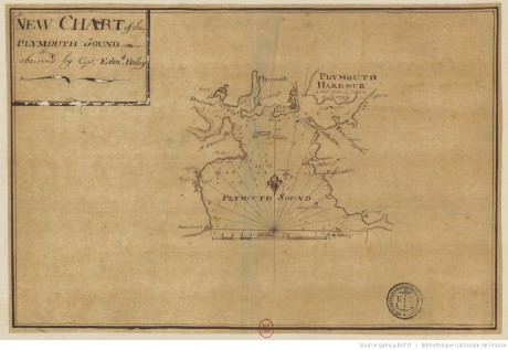
Manuscript version of the inset map of Plymouth Sound. The handwriting isn't Halley's hand, so was presumably made by another under his direction (@ Biblithèque Nationale de France, Image No xx)

Manuscript version of the inset map of Plymouth Sound. The handwriting isn’t Halley’s, so it was presumably drawn by another under Halley’s direction (© Bibliothèque Nationale de France, Image No GESH18PF23DIV5P16D)

The chart was incorporated into pilot books and reprinted many times throughout the eighteenth century, both in England and on the continent (you can view several examples on the BNF’s Gallica website here), although Halley isn’t always credited as the source in later editions. Halley’s performance probably secured him the mission to the Adriatic, where he was sent by Queen Anne to survey the Imperial coast for the purpose of identifying a harbour where English ships could overwinter during the War of the Spanish Succession. Halley made two trips to the area in 1702 and 1703, and not only identified a suitable harbour, but also directed its fortification. Ultimately the Royal Navy did not need to overwinter in the area, but Halley’s work was rewarded by the support of the Secretary of State in the election for the Savilian Professor of Geometry at Oxford, where success brought Halley’s seafaring days to a close.
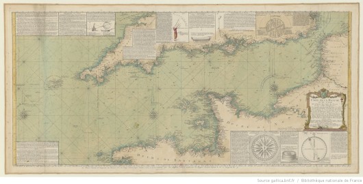
'Carte de la Manche' by the Chevalier de Beaurain 'd'Après les Observations du Scavant Capitaine Haley', 1778 (© Biblithèque National de France, Image No GESH18PF30P23)

‘Carte de la Manche’ by the Chevalier de Beaurain ‘d’Après les Observations du Scavant Capitaine Haley’, 1778. Beaurain has added a number of insets on astronomical and navigational instruments (© Bibliothèque Nationale de France, Image No GESH18PF30P23)

This final post has been horribly delayed by what Halley would call “Domestick Occasions”.

_______________

[1] TNA, ADM 1/1872, 13 Sept 1701.

[2] In fact, this may not have been the title when it was first published: I’ve looked at several versions of the chart and they all seem to have a slightly different title and it isn’t clear which one was Halley’s original.

[3] Thrower, Three Voyages of Edmond Halley, p. 345.

Instructions for Halley’s third voyage

In a previous post, we read Halley’s letter to the Lords of the Admiralty proposing a new voyage to make “an exact account of the Course of the Tides on and about the Coast of England”, which he claimed would be “a work of generall Use to all Shipping”. Their lordships quickly approved his proposal, and Halley set sail on his third voyage on 14 June 1701 – but what exactly was he doing? Here’re the Admiralty’s instructions:

Whereas his Maj[es]ties Pink the Paramour, is particularly fitted out and Putt under your Command that you may proceed with her, and observe the Course of the Tydes in the Channell of England, and other things remarkable, You are therefore hereby required and directed to proceed with the Said Vessell, and use your utmost care and Diligence in observing the Course of the Tydes accordingly, as well in the Midsea as on both shores; As alsoe the Precise times of High and Low Water of the Sett and Strength of the Flood and Ebb, and how many feet it flows, in as many, and at such certaine places, as may Suffice to describe the whole. And whereas in many places in the Channell there are Irregular and halfe Tydes you are in a particular Manner to be very carefull in observing them.

And you are alsoe to take the true bearings of the Princip[a]l head Lands on the English Coast one from another, and to continue the Meridian as often as conveniently you can from side to side of the Channell, in ord[e]r to lay downe both Coast truly against one another.

And in case dureing your being employed on this Service, any other Matters may Occur unto you, the observing and Publishing whereof may tend towards the Security of the Navigation of the Subjects of his Maj[es]tie or other Princes tradeing into the Channell you are to be very carefull in the takeing notice thereof: And when you Shall have p[er]formed what Service you can, with relation to the particulars before menc[i]o[n]ed, you are to returne with the Ship you Command into the River of Thames, giving Us from time to time an Account of your Proceedings Dated this 12° June 1701 [1]

These instructions can be summarised as:

  • to make observations of the behaviour of the tides in the Channel and along the English and French coasts
  • to take bearings that will allow the French and English coasts to be correctly situated north-south from one another
  • to take note of anything else that might lead to safer navigation in the Channel for traders

The first two points were copied almost verbatim from a letter of Halley’s dated the previous day (11 June), but the third point was added by the Admiralty, and it’s been suggested that it might represent an order for Halley to gather intelligence from French waters as the two countries slid towards war. [2] That idea has been given ballast by a 1693 diary entry made by Hooke, when Halley and business partner Thomas Jett were engaged in a salvage operation, that “Hally and Jed [were] Spys”. [3]

Now I have to admit that I’m far from indifferent to this notion of Halley as a secret agent but, like Alan Cook, I’m not wholly convinced by the idea in respect to his present voyage: the Admiralty instructions clearly refer to publishing Halley’s information and they express a concern with the safety of traders of all nations operating in the Channel.

A philosophical James Bond? (© Royal Society, ID xxx)

A philosophical James Bond? (© Royal Society, Image ID RS.9284)

That said, Halley’s earlier surveying activities do seem rather surprising, for example, he was apparently surveying the Thames approaches in early 1689, during the politically-sensitive aftermath of the so-called Glorious Revolution. I’ve started to trawl through the government archives to see if I can unearth anything that indicates whether he was ever employed on intelligence work, but I’ve encountered nothing as yet – though I’ll be sure to reveal such state secrets here if I do!

_______________

[1] National Archives, ADM 2/27, pp 131-2.

[2] See Cook, Edmond Halley: Charting the Heavens and the Seas (Oxford, 1998) pp 285-6, but note that Cook refers to a published mistranscription of Hooke’s remark.

[3] Hooke, Diary, 24 March 1693, British Library, Sloane MS 4024.

Halley’s maritime experience, part 1: Hally a Sayling

We looked at how Halley came to be given command of a Royal Navy ship during his first voyage and I said we’d examine what experience he had to justify that commission during his second: this we’ll do now in a two-part special.

In fact Halley had minimal maritime experience – although perhaps rather more than your average seventeenth-century natural philosopher – but the experience he did have was of three types: as a passenger, as a surveyor, and as a diver.

Halley was a passenger on three voyages as a young man, the first when he abandoned his degree in 1676 to sail to St Helena to map the southern stars. The two-way voyage on an East Indiaman would have taken about 5 months, and as Halley seems to have had a life-long interest in maritime matters, it seems reasonable to assume he took the opportunity to observe how the ship was sailed, how the crew operated, and to pick up a smattering of nautical terminology.

One year after his return from St Helena, he was at sea again en route to visit the great astronomer, Johannes Hevelius, at Dantzick (Gdańsk) on the Baltic coast, and at the end of the following year, 1680, he crossed from Dover to Calais (and was apparently seasick) to begin his Grand Tour, returning to England from Holland in January 1682. [1] Again, it seems fair to expect that he paid at least some attention to the handling of the ships.

At the end of the decade, Halley progressed from maritime passenger to coastal surveyor, although his work as a surveyor is rather obscure, being largely inferred from his presentation of two charts to the Royal Society, the first of which appeared in the minutes for 3 July 1689:

Halley produced his Sea-draught of the Mouth of the River of Thames, wherein he saith, that He hath corrected severall very great, and considerable faults in all our Sea-Carts [sic] hitherto published. [2]

It isn’t known for sure when he undertook his survey of the Thames approaches but Robert Hooke recorded two entries in his diary – “Hally a Sayling” on 22 March 1689, and “Hally Returnd” on 3 April – which may relate to his surveying, although the previous summer Halley had made several references to towns near the Thames estuary which may indicate that he had been surveying in the area at that time. [3]

His second survey, “of the West coast of Sussex between Selsey and Arundell”, was presented to the Society on 15 November 1693, [4] and this time we have rather more idea about the circumstances behind its production because this chart was a by-product of his diving activities.

Halley first wrote about diving in a paper of 6 March 1689, and his interest was probably prompted by the recent success of Captain William Phips’s diving operation in the West Indies, where Phips recovered a spectacular haul of treasure from a Spanish wreck and sparked a tsunami of projects connected with diving and salvage. [5] Halley proposed a mobile diving bell built on four wheels, and while he didn’t build that particular bell, he did build another as part of his salvage work on the wreck of the Guynie frigate.

The Guynie was owned by the Royal African Company (RAC) and in early 1691 she returned from Africa to English waters, having collected “Bees Wax & Elephants Teeth” from Gambia and “Elephants Teeth & Redwood” from “Sereleon” (Sierra Leone). [6] On 23 February her commander, William Chantrell, wrote to the RAC from Falmouth requesting a convoy to accompany him back to London. The RAC instructed three of their most senior officers to “waite on the Lords of the Admiralty to gett a Man of Warr to Convoy the Guynie Friggott up from Falmouth”, which might seem a little excessive for beeswax and ivory, but the Guynie was carrying something much more valuable on board. [7]

Captain Chantrell had undertaken to deliver a large quantity of gold on behalf of the Portuguese in Africa, and it was on this account that a convoy ship had been requested. [8] The Guynie sailed from Falmouth on 26 March, but on 4 April Captain Chantrell wrote from Chichester to advise the RAC that the ship had foundered. [9] It isn’t clear what happened to the ship, but there’s no mention of any lost men and the gold seems to have been saved, as on 8 April the RAC ordered that “a Guard of Tenn Soldjers & an Officer be sent from hence to fetch the Gold (saved out of that Shipp) from Chichester”. [10]

The ivory, however, went down with the ship, and it’s in this regard that Halley now appears in the affair. The Deputy Governor of the RAC was Royal Society fellow, Abraham Hill, and it may have been he who brought Halley in to try to salvage the elephants’ tusks. Halley’s initial plan was certainly ambitious as on 13 May 1691 the Royal Society minutes record that “Halley shewed the Method he intended to use in raising the Ship”, but this plan was evidently modified as on 12 August he was relating “the Success of his Experiments of going under water in his diving bell”.

Halley believed his diving bell had limitless possibilities, and on 15 September a government warrant was issued to prepare a bill granting Halley and three partners “sole use of their invention of a new engine never yet known”, and Letters Patent were issued on 15 October. On 17 November, the four patent-holders formed a joint-stock company with two other men, John Carter and Thomas Jett, who was a friend of Halley’s. [11]

Halley's signature on the agreement forming the joint-stock company (© National Archives, C 111/192)

Halley’s signature on the agreement forming the joint-stock company (© National Archives (£), C 111/192)

Thomas Jett, incidentally, is interesting because he is the “Jed” in Hooke’s Diary entry for 24 March 1693, “Hally & Jed Spys”, which offers a hint (there are one or two others) that Halley may have undertaken coastal surveys on behalf of the government. [12]

Halley and Jett appear periodically in the RAC minutes until about spring 1694, though their level of success in salvaging the tusks is unclear – and by that time Halley had become involved in the scheme with Benjamin Middleton to obtain a ship to sail around the world, which, when the scaled-down version of the project finally got underway in late 1698, would see Halley drawing on all his modest maritime experience to serve as the Paramore‘s commander. [13]

In part 2 of this post about Halley’s nautical experience, we’ll take a much closer look at his diving bell – and at my favourite thing about him!

_______________

[1] Hooke to Halley, 1 March 1681, Royal Society, EL/H3/62; Hooke, Diary, 24 Jan 1682, London Metropolitan Archives.

[2] Royal Society, Journal Book Original, JBO/8 p 268.

[3] Hooke, Diary, 22 March 1689 and 3 April 1689, British Library, Sloane MS 4024; references to towns in RS, JBO/8.

[4] RS, JBO/9 p 141.

[5] For a fair copy of Halley’s paper, see RS, RBO/7/24.

[6] RAC Instructions to Captains, The National Archives, T 70/61 ff87r-88v.

[7] RAC Minutes, TNA, T 70/83.

[8] RAC Black Book, TNA, T 70/1433 p 104.

[9] TNA, T 70/83 f8r.

[10] Ibid.

[11] CSP, D, 1690-91; TNA C111/192.

[12] BL, Sloane MS 4024. Many thanks to Hooke’s editor Dr Felicity Henderson for confirming this entry as it has hitherto appeared mistranscribed.

[13] I’ve read suggestions that Halley and Jett only recovered one tusk, but that is based on a mistranscription of the phrase “the elephants teeth”, where the e’s in teeth are akin to the Greek letter theta (ϑ) and have been misread as ‘oo’. This style of ‘e’ was common in the 17th century and Halley himself used it. He later told Hans Sloane that his attempt to recover the ivory had been frustrated by the wreck quickly becoming covered with “Sand and Oase”.